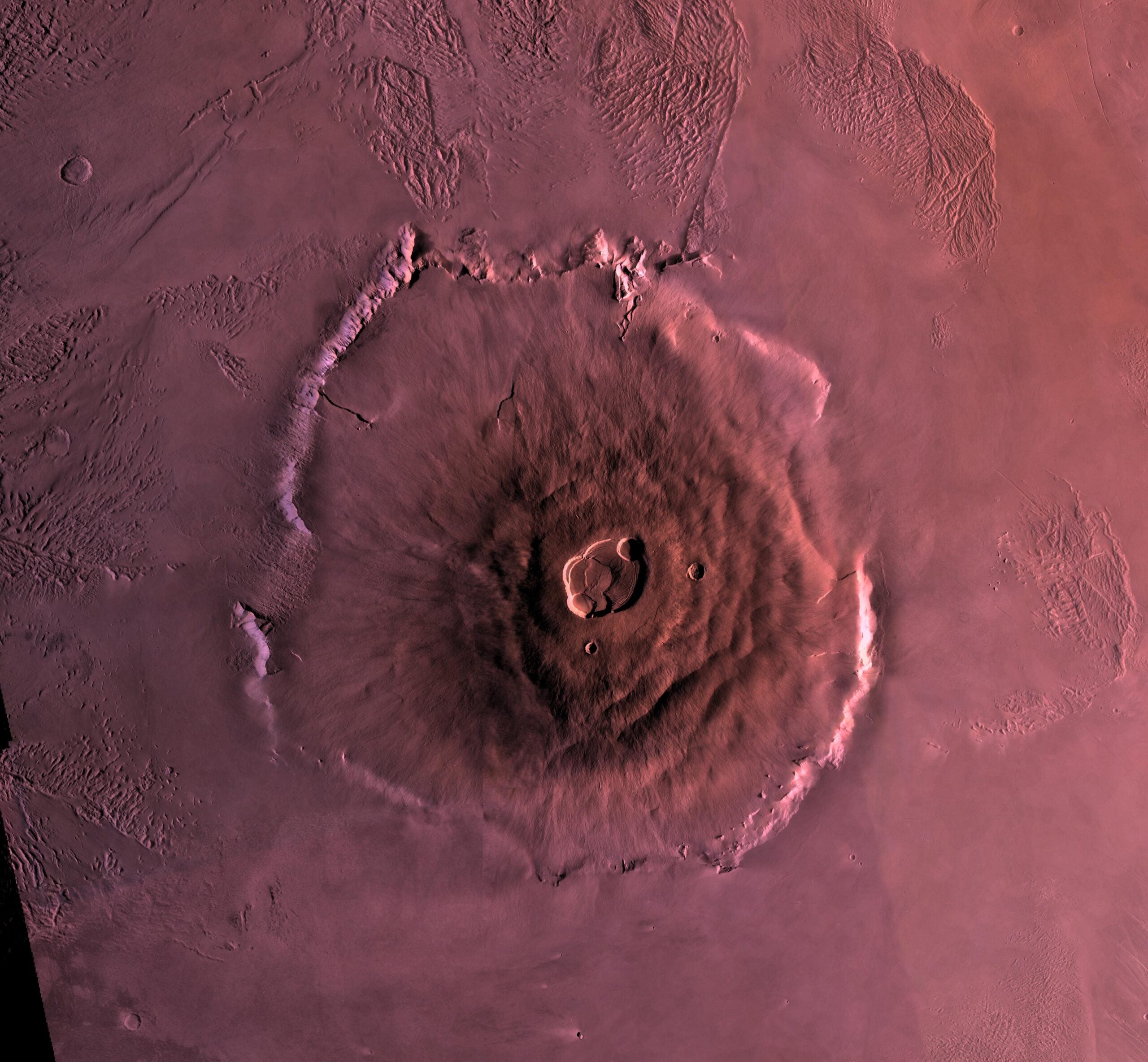
If you approached Olympus Mons from the Martian plains, the first thing you met might not be a gentle incline.
It could be a wall.
Much of the volcano ends in a basal escarpment several kilometres high. Along some sections, published measurements put that cliff close to nine kilometres from bottom to top. It is a vertical interruption taller than Mount Everest is high above sea level, attached to a volcano whose upper flanks are routinely described as so shallow that a traveller might not realise they were climbing at all.
That contradiction is the beginning of the real Olympus Mons.
The familiar account says the volcano rises roughly three times as high as Everest, spreads across about 600 kilometres and slopes so gently that its summit would sit beyond the Martian horizon. The ground would look almost flat. The mountain would be too large to see.
There is truth in that picture, but every part of it needs a qualification. Olympus Mons does not have one agreed “base”. Its quoted height changes with the reference surface. A five-degree slope is gentle for a volcano but noticeable to a person walking uphill. Most importantly, simple horizon geometry does not make the summit categorically invisible from every point on the margin.
What a person could not see is the volcano as a whole. Olympus Mons is not a larger version of an Earth mountain. It is a regional landscape that happens to have been built by lava.
The Everest comparison begins with two different zeroes
Mount Everest is 8,848.86 metres above mean sea level. That number is precise because Earth has oceans and a globally defined reference surface. It is not the vertical rise a climber sees from the Tibetan Plateau, which is already several kilometres above sea level.
Mars has no ocean surface from which to start. Planetary scientists use a reference areoid or datum, an equipotential surface that plays a role similar to sea level. They can also measure relief from the surrounding plains, the foot of a scarp or another locally chosen base.
Older Viking-era descriptions often called Olympus Mons about 27 kilometres high. NASA’s PIA00300 Viking mosaic description still uses that figure and gives a base width above 600 kilometres. Modern laser-altimeter-based studies commonly put its summit elevation and local relief closer to 22 kilometres, depending on exactly what is measured.
This is why one source says nearly three Everests and another says roughly two and a half. Twenty-seven divided by 8.85 is just over three. Twenty-two divided by 8.85 is about 2.5. Neither ratio tells you what a person would see because both compare unlike reference levels.
A 2004 morphometric analysis by planetary scientist Jeff Plescia measured Olympus Mons as an edifice roughly 840 by 640 kilometres when the broader construct and its lava-covered margins are included. It gave a relief of about 22 kilometres and an exposed volume of 2.4 million cubic kilometres, comparable to the volume of the entire Hawaii-Emperor volcanic chain.
The popular 600-kilometre width is therefore useful as an order of magnitude, not a surveyed fence line. Olympus Mons becomes larger or smaller on a map depending on whether the mapper includes scarp-draping flows, the basal escarpment and the immense aureole deposits beyond it.
“Standing at the base” could mean standing beneath a nine-kilometre cliff
The phrase “at the base” suggests the foot of an ordinary mountain, where a rising flank meets a plain. Olympus Mons refuses that simplicity.
A scarp nearly surrounds the main shield. ESA’s Mars Express account of the volcano’s southeastern foot says the cliff reaches nine kilometres in places. A 2016 study of the volcano’s structure measured similar maximum heights and slopes around 30 degrees along pronounced sections.
If you stood on the lowland plain immediately below one of those sections, you would know there was a landform in front of you. You would not see a shallow ramp disappearing imperceptibly into the sky. You would see broken terrain rising through more vertical distance than almost any comparison on Earth can comfortably convey.
Other parts of the margin are different. Lava has spilled over and buried sections of the scarp, producing gentler approaches. Plescia measured slopes of roughly two to six degrees on some scarp-draping flows to the east and southwest. A route chosen through one of those sectors could move from plain to flank without confronting the full cliff.
This does not make the “flat mountain” idea false. It tells us that the experience depends on where the traveller arrives. Olympus Mons is not radially uniform. It has terraces, graben, lava channels, steep scarps and smoother aprons. There is no single view called “the base”.
The scarp’s origin is itself not completely settled. Landslide models are supported by the enormous ridged aureole deposits spread beyond the volcano. A 2014 structural analysis of the eastern basal scarp found evidence consistent with large-scale slope failure and a basal detachment. Other work has examined erosion, gravitational spreading and even whether the volcano’s lower shape retains traces of interaction with an ancient ocean.
The neat cone in a textbook has been broken, spread, buried and rebuilt.
A gentle volcanic slope is not the same as flat ground
Olympus Mons is a shield volcano, constructed largely from fluid lava that travelled outwards rather than piling into a steep fragmental cone. Its broad flanks average about five degrees in the Plescia measurements.
Five degrees sounds negligible. It is not visually dramatic, but it corresponds to a grade of about 8.7 per cent. Many roads treat that as a serious sustained climb. A person would feel it in their legs and see loose objects tend downhill, even in Martian gravity.
Some popular accounts accidentally exchange five degrees for a five per cent grade. A five per cent grade is only about 2.9 degrees. Across a structure hundreds of kilometres wide, that difference adds kilometres to the implied height.
A simple average also hides the terraces. Research on lithospheric flexure and gravitational spreading describes upper and middle-flank terraces, lower radial scarps, troughs and a summit caldera complex. The five-degree figure belongs to the whole flank, not every metre of a possible route.
What would look flat is the short section available to the eye at any one time. A person standing 1.7 metres above a perfectly spherical Mars has a geometric horizon only about 3.4 kilometres away. Over that interval, a five-degree plane rises by roughly 300 metres. You would recognise an incline, but you would not see it gather into a distant triangular summit. The ground would simply continue upward until it met the sky.
That distinction matters. “You would not see a mountain” is plausible. “You would not know you were ascending” is much harder to defend.
The summit is not automatically beyond the horizon
The most repeated Olympus Mons claim says the summit would be beyond the horizon from the base. It sounds inevitable because the summit may be 300 kilometres away and a standing observer’s horizon is only a few kilometres.
But an elevated object can project above the horizon even when its base is hidden. We see this on Earth whenever a distant mountain appears above the curvature that conceals the land below it.
Using JPL’s mean Martian radius of 3,389.5 kilometres, the approximate line-of-sight distance to a geometric horizon is the square root of twice the planet’s radius multiplied by the observer’s height. For eye level at 1.7 metres, the result is about 3.4 kilometres. For a point 22 kilometres above the plains, it is about 387 kilometres. At 27 kilometres, it is about 429 kilometres.
This is a simplified calculation, not a prediction of what an astronaut would photograph. It treats Mars as a sphere, Olympus Mons as an elevated target and the atmosphere as perfectly transparent. It ignores the actual terrain profile between observer and summit.
It is enough to show why the categorical version fails. If the volcano is treated as 600 kilometres across, its centre lies about 300 kilometres from the margin, within the geometric visibility distance of a 22-kilometre summit. If the broader 840-by-640-kilometre edifice is used, the distance from centre to margin ranges from roughly 320 to 420 kilometres. A high point could clear the planetary horizon from some directions and fall below it from others.
The terrain can still hide it. A shield is not a tower standing behind a flat plain. Its convex flank occupies the line of sight, and terraces or caldera walls may block more distant ground. Dust and haze can remove contrast. The summit is also a broad plateau and caldera complex, not a sharp white peak that announces itself against the sky.
The defensible statement is therefore subtler: from much of Olympus Mons, you would not see a recognisable summit or the full mountain profile. It is not defensible to promise that every elevated part of the summit must be geometrically below the horizon from every point called the base.
The summit is a landscape almost 90 kilometres across
Everest ends in a point narrow enough for climbers to queue on it. Olympus Mons ends in a volcanic complex large enough to contain a city and its surrounding region.
The summit contains six overlapping collapse calderas. Depending on how their outer boundary is measured, the complex reaches up to about 90 kilometres across and around three kilometres deep. ESA’s first complete high-resolution colour view covered an area about 102 kilometres wide just to frame it.
Those depressions formed through repeated episodes in which magma was withdrawn and the unsupported rock above subsided. They are not one impact crater and not one simple vent. Their overlapping floors and walls record multiple collapses.
Reaching the summit would therefore not produce the familiar experience of looking down from a peak. A traveller could arrive on a high plateau, cross faulted and lava-covered ground, and then encounter a caldera wall kilometres deep. The summit itself contains horizons.
This helps explain why orbital images are so deceptive. From above, the whole shield fits inside a frame and the caldera provides an obvious centre. The brain turns the image into a mountain. On the surface, that organizing view disappears. There is no camera position from which a person can simultaneously take in the outer aureole, basal scarp, hundreds of kilometres of flank and nested summit pits.
I have written before about how Ingenuity turned aerial perspective into a practical tool on Mars. Its downward-looking navigation camera tracked local texture so the helicopter could estimate motion. Olympus Mons poses the inverse problem: a person on the ground has abundant local texture but no viewpoint high and distant enough to reveal the object they are standing on.
The ascent is a journey across a region, not a climb up a face
Suppose a route avoided the highest scarp and ran approximately 300 kilometres from the outer flank to the summit region. Gaining 22 kilometres across that horizontal distance gives an average angle a little above four degrees, close to the measured flank values.
At ten kilometres of progress per day, the horizontal journey alone would take about a month. That estimate says nothing about route-finding, lava channels, terraces, pressure-suit limits, power, dust, radiation or the severe fall in atmospheric pressure as the traveller climbs.
For comparison, Opportunity drove 45.16 kilometres across fourteen and a half years. The rover was not trying to travel quickly, and its route was shaped by science targets, hazards, winters and ageing hardware. Still, its entire historic traverse would cover only a fraction of one Olympus Mons flank.
A future pressurised rover could move much faster. Even then, ascent would resemble an overland expedition more than mountaineering. The challenge would be maintaining life and machinery across a long, rising surface with no nearby rescue, not finding handholds on a steep wall.
Near the summit, the already thin Martian atmosphere becomes thinner still. Mars’s surface pressure varies strongly with elevation, season and weather. Olympus Mons extends through a large fraction of the atmosphere’s effective vertical scale, so a habitat or vehicle designed for lower plains would need to account for a substantially different external pressure and thermal environment.
Lower gravity reduces a traveller’s weight, but not the mass that must be accelerated or stopped. A loaded vehicle can still slide. A suit still resists motion. A journey of hundreds of kilometres still consumes food, energy and time.
Mars did not simply let one volcano sit over a hole forever
The standard explanation for Olympus Mons says Mars lacks plate tectonics, so its crust remained above one mantle hot spot while lava accumulated for billions of years. Earth’s moving Pacific Plate, by contrast, carries Hawaiian volcanoes away from their source and creates an island chain.
That comparison is useful, but it can make the volcano sound like a stationary nozzle beneath a rigid floor. The geological history is more complicated.
Mars does not have Earth’s present system of globally mobile plates. Its thick lithosphere could support a much larger load, while lower gravity reduced the stresses created by the volcano’s own mass. Repeated eruptions spread basalt over immense distances. At the same time, the edifice flexed the crust beneath it, spread outward under gravity, developed terraces and faults, and suffered enormous flank failures.
The aureole mapped by Mars Express extends as much as 1,000 kilometres from the summit in some directions. Its ridges and blocks are evidence that the volcano’s history includes lateral movement on a scale comparable to countries.
Crater counting has also placed some lava surfaces far later than the volcano’s initial construction, although those ages are model estimates rather than observed eruption dates. No human has watched Olympus Mons erupt, and calling it active, dormant or extinct imports terrestrial categories into incomplete evidence.
The safest conclusion is that the edifice accumulated over a very long span and was modified repeatedly after its basic shield shape existed. Olympus Mons became enormous not because Mars removed every limit on volcanoes, but because the limits were different: gravity, lithospheric strength, magma supply, erosion and crustal motion combined in a way Earth does not reproduce.
The mountain is visible only after you leave it
The original thought experiment survives, but in a corrected form.
Stand on a smooth section of the flank and the horizon would show tilted volcanic ground rather than a peak. You could know you were climbing from instruments, effort and the changing pressure without seeing the volcano’s outline. Move to the foot of a major scarp, however, and the claim of an almost-flat base collapses into a cliff kilometres high.
Look toward the summit from the margin and the highest terrain may or may not clear the geometric horizon. The answer changes with route, edifice definition and intervening topography. Even if part of the summit were visible, it would not resemble Everest. A broad rise or distant rim is not the same as seeing a mountain.
The one view unavailable from the ground is the view that made Olympus Mons famous: the complete shield, with its central caldera, encircling scarp and petal-like aureole spread across the Tharsis plain.
To see that object, you need an orbiter, a map and an artificial perspective assembled from thousands or millions of measurements. Human eyes on the surface would receive fragments: a slope, a lava channel, a terrace, a cliff, a caldera wall.
Olympus Mons is nearly invisible as a mountain not because it lacks relief, but because it exceeds the scale at which a mountain can present itself to one observer.
You could cross it for weeks, climb higher than any point on Earth and still never encounter the single moment when the landscape ahead resolves into the volcano beneath your feet.