

A northern ocean on ancient Mars would have occupied the planet’s most obvious empty container. The northern lowlands sit several kilometres below the heavily cratered southern highlands and cover an immense fraction of the globe. Fill that basin with water and a plausible ocean appears almost automatically.
The difficult part has always been proving that the basin was actually filled. Mars has river valleys, deltas, lake beds and minerals altered by water, but those features do not require a single northern ocean. Proposed coastlines wander up and down in elevation where an undisturbed shoreline should follow a level surface.
Two studies published in 2025 approached that old problem without simply drawing another line around the basin. One looked beneath the wheels of China’s Zhurong rover and found the internal architecture expected under a beach. The other examined ancient rivers at Aeolis Dorsa and found the upstream response expected when rivers meet a large standing body of water.
They are independent fingerprints in a careful sense. Different teams used different instruments at widely separated sites to identify different parts of a coastal system. Neither study saw water, neither proves that the body was global, and they do not establish that both deposits formed at the same time. Together, however, they make the vanished-ocean hypothesis harder to dismiss as a resemblance drawn only on the surface.
The ocean hypothesis has always had a shoreline problem
Mars’s hemispheric dichotomy provides a basin, and enormous outflow channels show that catastrophic floods once emptied toward the northern plains. Orbital images have revealed candidate shorelines, sedimentary fans and the widespread Vastitas Borealis Formation, a late-Hesperian unit that may contain material deposited by water.
Yet a shoreline is unusually vulnerable evidence. Wind can bury it, impacts can interrupt it and later erosion can erase the low-relief forms that distinguish a beach from an ordinary slope. Loading by volcanoes and changes in the planet’s orientation may also deform an originally level coast. Large unexplained elevation differences among proposed shoreline segments have therefore kept the ocean controversial.
As SpaceDaily previously explored in its overview of Mars’s long wet history, the argument is no longer about whether liquid water existed. It is about its scale, duration and connection. A crater lake can explain a delta inside a crater. A northern ocean must explain coast-like deposits across an open basin.
Zhurong looked below a surface that time had rearranged
Zhurong landed in southern Utopia Planitia on 15 May 2021 as part of China’s Tianwen-1 mission. Before entering hibernation in May 2022, the rover travelled 1,921 metres and repeatedly sounded the ground with the Rover Penetrating Radar, or RoPeR.
RoPeR has a high-frequency channel for fine shallow detail and a 15-to-95-megahertz low-frequency channel capable of probing much deeper. In the February 2025 Proceedings of the National Academy of Sciences study, Jianhui Li, Hai Liu and ten colleagues processed the low-frequency record along a route that cut roughly across previously proposed shorelines.
The rover was about 280 kilometres north of, and roughly 500 metres below, some mapped shoreline candidates. On the modern surface there is no recognisable strand where waves once broke. Radar supplied a cross-section through what later regolith had concealed.
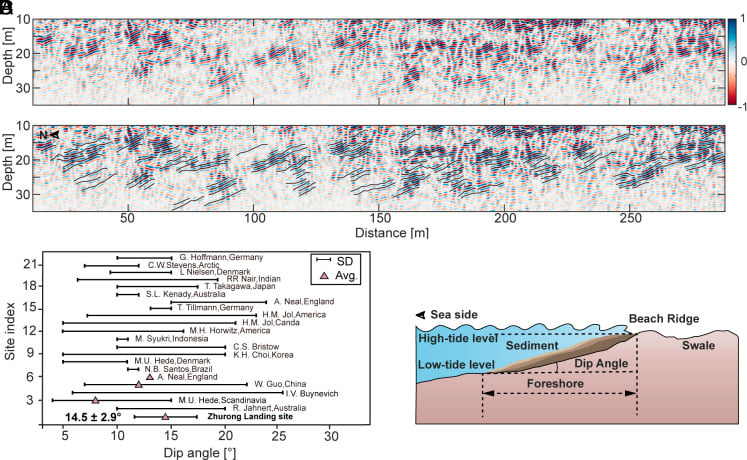
The team identified 76 reflectors at depths from 10 to 35 metres. All dipped toward the northern lowlands. Their inclinations ranged from 6 to 20 degrees, averaging 14.5 degrees with a standard deviation of 2.9 degrees, and they appeared broadly across a shoreline-perpendicular traverse longer than 1.3 kilometres.
That consistency matters more than any single sloping layer. A buried dune, lava flow or river deposit can also create an inclined radar reflection. A stack of similarly directed layers spread along a long transect records a repeated process building ground outward toward the basin.
Why the radar layers resemble a beach
On a prograding coast, waves and currents move sediment along and across the shore. New sand and gravel accumulate on the foreshore, shifting the shoreline toward the water while preserving seaward-dipping layers beneath it. Repeated changes in water level and sediment supply build a stack rather than a single surface.
The Martian reflector angles sit inside the 4-to-26-degree range the authors compiled from 21 coastal environments on Earth. Radar sections from the Bay of Bengal displayed comparable parallel layers dipping toward the lowland side. Some weaker southward reflectors at the Zhurong site joined the dominant northward ones into dome-like forms that the team interpreted as beach ridges behind the swash zone.
Electrical properties offered another constraint. The inferred relative permittivity ranged from about 3 to 7, averaging 4.4. That is compatible with sediments dominated by silt and fine-to-medium sand with a smaller pebble fraction. Typical lava flows are closer to 9 and do not usually produce the same extensive parallel architecture.
The researchers also tested two other familiar alternatives. Rivers can leave dipping beds, but the flat area around the traverse lacks the valley networks or channel dissection expected from a fluvial origin. Wind-built dunes contain cross-beds whose direction and steepness vary through the dune. The radar did not show that changing, cross-bedded pattern.
For those reasons the authors concluded that coastal deposition was the most consistent explanation. They inferred a distant river supplying sediment, then waves or tides moving it along a stable shore. A small temporary meltwater pond would provide too little open-water distance, or fetch, for sustained wave transport across the observed reach.
The paper went further and suggested that accumulating a section this extensive could represent tens of millions of years, using terrestrial coastal deposition rates of roughly 10 to 40 centimetres per thousand years. That is an analogue-based estimate, not a direct Martian clock. The timing and duration of the shoreline’s advance and retreat remain weakly constrained.
Aeolis Dorsa preserved rivers in reverse relief
The second fingerprint lies not under a rover but in orbital images of southeast Aeolis Dorsa. The region contains winding ridges and plateaus that began as low river channels. Coarser sediment accumulated in the channel beds and hardened. Wind later removed the finer, softer floodplain around them, leaving the old bottoms standing above their surroundings in topographic inversion.
Cory Hughes of the University of Arkansas led the 2025 Geophysical Research Letters study with John Shaw, Andrew Fernandes and Timothy Swanson. They mapped nine channel belts using images from the Context Camera aboard NASA’s Mars Reconnaissance Orbiter. The camera data resolve about six metres per pixel, while stereo-derived elevation models were sampled at 18 metres per pixel.
A channel is the path occupied at one moment. A channel belt is the wider zone across which a river migrates over time, leaving sandstone bodies that can be hundreds of metres across. The nine Martian belts ranged from 16 to 1,395 metres wide, and the researchers estimated characteristic channel widths from 36 to 155 metres.
Their question was not merely whether the ridges looked like rivers. It was whether their preserved geometry contained the hydraulic response of rivers approaching standing water.
Backwater begins upstream of the water’s edge
Where a river enters an ocean or large lake, the downstream water level begins influencing the river before it reaches the mouth. Its bed drops below the receiving water’s level, flow becomes non-uniform and sediment transport changes. This reach is called the backwater zone.
During ordinary flow, water can slow and deposit sediment. During floods, the water-surface slope steepens and the same reach may erode. Repeated alternation encourages sediment to build near the upstream start of the zone and can push the river to jump into a new course, an event called avulsion.
Terrestrial deltas preserve a useful geometric signature. Near one backwater length upstream from the coast, the channel belt narrows sharply relative to the active channel. Hughes and colleagues searched the Martian belts for that narrowing and compared it with a putative shoreline mapped in earlier work.
The inferred backwater lengths ranged from about 5 to 17 kilometres, with an average of 9.2 kilometres. Eleven preserved avulsion nodes occurred between 0.8 and 1.2 backwater lengths from the coast. Another eleven were within a factor of two, and all identified nodes were within a factor of three.
That colocation is the second layer of the argument. The belts do not only narrow where coastal-river theory predicts. The points where rivers abandoned their old paths also cluster at the scale expected when floods repeatedly disturb a mature delta.
The derived slopes and grain sizes have substantial uncertainty because the channels are eroded and seen remotely. The authors estimated backwater lengths partly from empirical relationships developed on Earth. They nevertheless found that the overall dimensions resemble long-lived lowland deltas rather than small fans trapped inside craters. In the University of Arkansas account, Hughes described the evidence as favouring an ancient ocean, or at least a large sea.
Two fingerprints are stronger because they are not copies
The Zhurong study starts at the receiving basin. It asks whether buried sediment beneath Utopia Planitia has the internal slopes, electrical properties and continuity of a coast. The Aeolis Dorsa study starts with the rivers. It asks whether their channel belts changed upstream in the way rivers change when controlled by a large downstream water level.
The methods have different weaknesses. Radar interpretation can confuse geological materials that reflect radio waves in similar ways. Orbital reconstruction must infer the original width and elevation of deposits after billions of years of erosion. An error that manufactured a beach-like radar stack would not automatically manufacture nine correctly scaled backwater zones and avulsion patterns elsewhere.
But “independent” should not be stretched into “conclusive.” The sites are far apart, the deposits are not shown to be synchronous and a large regional sea can generate both coastal and backwater geometry without covering the entire northern basin. The Zhurong layers belong to a late-Hesperian setting, while the absolute age of the Aeolis Dorsa channel system is not fixed by these geometric measurements.
Nor do the papers solve the uneven-shoreline problem. A successful ocean model still has to connect deposits of the right ages and elevations after accounting for later deformation of Mars. The new work adds process-based evidence; it does not turn every previously proposed line into a real coast.
The missing water has not all followed one path
If a sustained northern sea existed, early Mars needed an atmosphere thick and warm enough to keep regional surface water stable, at least intermittently. The coast would have linked river sediment, standing water, wind, waves and perhaps tides. Interfaces like that concentrate minerals and organic material, making ancient shore deposits attractive targets in the search for preserved signs of habitability.
Then the climate changed. Mars lost much of its atmosphere, surface pressure fell and stable open water disappeared. As SpaceDaily reported in its examination of Mars’s missing water, some escaped to space while a large fraction may remain stored as ice, hydrated minerals or water in the crust.
The most decisive next evidence would connect geometry to material. Higher-resolution radar could trace the Zhurong reflectors over a larger area. A future lander could image grain textures, identify wave-worked sediment and date minerals within the layers. Samples from an inferred foreshore could test whether the deposit records sustained briny water, a short-lived lake or something unrelated to a coast.
For now, the case rests on what vanished water made matter do. Beneath Utopia Planitia, sediment leans toward an absent basin. At Aeolis Dorsa, rivers narrow and change course as though a fixed body of water once resisted them downstream. Mars’s possible ocean has not survived as a blue surface or an unbroken beach. It may have survived as two kinds of geometry, one under the shore and one written back through the rivers that reached it.