The night the smoke closed over Green Bay
The Wisconsin Historical Society’s 2023-2024 field report sets the scene in two flat sentences: in early October strong winds, extreme heat and dry conditions fueled several forest fires across the region, and large fires burned unabated for days.
Two of them acquired names. The one that consumed large sections of Chicago from 8 to 12 October became the Great Chicago Fire, and the one that burned through northern Wisconsin became the Peshtigo Fire. The report is careful to add that many other forest fires burned days before, and others flared up after.
Dense smoke hung over Green Bay. On 8 October the schooner G.L. Newman left Suamico and sailed almost blind into it. According to the field report, Captain Le Prevost became disoriented, made an error in navigation, and at 9pm ran the vessel onto the southeast point of Green Island, a spot the lake trade knew as Green Island Reef.
The island had a lighthouse, and the keeper was Samuel P. Drew. The Society’s own vessel record for the G.L. Newman preserves the detail that fixes how bad the visibility was: Drew had kept the light lit during the day.
He got the crew ashore and put them up in the lighthouse. They remained on the island for more than a week, salvaging what they could off the ship.
On 19 October, Captain J.F. Trowell of the schooner Saginaw reported that the Newman was full of water, its cabin washed away, and that he presumed the ship would be abandoned. Attempts were made to pull the hull off the shoal and none of them worked. By the vessel record’s account a small boat came up from Racine on 23 November to recover the rigging.
The ship stayed on the insurance rolls in hope of salvage through 1873. On 31 March 1874 its enrollment was surrendered at the port of Milwaukee, and the stated cause was a total loss.
From a Black River yard to the Green Bay shingle runs
The ship’s paper trail is thick, if not complete. Master Carpenter Benjamin Flint built the G.L. Newman at Black River, Ohio in 1855, the second and last vessel he built.
The enrollment described it as schooner-rigged with two masts, one deck, a plain head and a square stern, measuring 123 and a third feet long, 26 and three-quarter feet in beam, with a depth of hold just over 11 feet. Its tonnage was calculated at just over 337 tons. It was registered at Cleveland on 28 April 1855, with Flint as its first captain.
The name belonged to a Buffalo grocer and ship chandler. George Lissant Newman was born at Newark upon Trent, Nottinghamshire, in July 1816, emigrated to Buffalo at fourteen, and clerked at the firm that preceded the one he later ran with Captain Asa E. Hart.
Two Black River investors put up most of the shares. The hotelier and former sailor Conrad Reid, later the first mayor of Lorain, Ohio, and the quarry owner Henry Ephraim Mussey took seven-sixteenths each, with Flint keeping two-sixteenths.
Across seventeen seasons the ship carried what everything on the lakes carried. Grain east to Buffalo and Oswego, coal and pig iron and railroad iron west, shingles and lath and posts down from the Wisconsin lumber ports.
It also collected the ordinary damage of the trade. In 1856 it collided with the brig Sultan off Middle Island near Presque Isle and jettisoned 70 tons of coal, and in 1857 it went ashore in fog in the Straits of Mackinac. In 1859 it struck and carried away the lighthouse on Racine’s north pier, and the harbormaster demanded that the captain and owners pay for it.
The ownership and the command changed hands about as often as the ship got into trouble, through eight or nine changes of owner and a long succession of masters, two of whom were never entered in the ship’s documents at all. A defaulted mortgage put the ship on the block in December 1858, and the Oconto Lumbering Company bought it at public auction.
The rig moved too, and the report tracks it without settling it. The new enrollment in April 1859 described three masts rather than two, and the report says it is not known when that change happened. Minor repairs in 1861 likely took it back from three to two, also unrecorded, and the 1863 enrollment has the ship returned to a two-masted configuration. The two Society documents part here as well: the vessel database lists the ship as a three-masted bark, while the field report says it was always registered as schooner-rigged, notes that contemporary newspapers variously called it a schooner, barque or barkentine, and concludes it was probably a topsail schooner that confused reporters.
One more number matters for what follows. After repairs from a collision with the schooner Ithaca, the Newman was remeasured in 1865 under the Congressional Act of 6 May 1864, at 122.3 feet long, 26.3 feet in beam and 10.9 feet in depth of hold, with its tonnage reported as 249.47 tons. A new permanent enrollment was entered at Chicago that July, and those became the official numbers.
By 1871 the Newman was working the Green Bay ports. The season’s recorded runs were shingles from Suamico to Milwaukee in June, August and September, and the ship sailed from Suamico again on 8 October.
Identification without a nameboard
The Society’s own two documents do not agree on whether the wreck has been identified.
Its vessel database says that through historical research the wreck was positively identified as the G.L. Newman. The field report, written by Tamara L. Thomsen and Kendra A. Kennedy and published as State Archaeology and Maritime Preservation Technical Report Series #25-001, says something narrower in its site description: given the wreck dimensions, location, and a comparison of vessel losses in the vicinity based on historic newspaper accounts, the vessel remains were determined to likely belong to the schooner G.L. Newman.
Its conclusions chapter is narrower still, and states the failure outright. The first objective of the survey, to provide positive vessel identification through identifying marks or artifacts, was not achieved.
The ship’s nameboards were not present. Painted areas and identifying marks were covered with quagga mussels.
The report allows that the location and the evidence of the wrecking event match, and says a complete archaeological documentation of the site will be a continuing process for years to come.
That distinction is doing real work. An identification built from dimensions, position and a newspaper loss list argues by elimination: these are the right measurements in the right place, and of the vessel losses the newspapers record in the vicinity, one fits. An identification built from a nameboard, a marked fitting or a registered number is direct evidence.
Dimensions carry more of the load here than they look like they should. The Newman has two sets of official numbers, 123.33 by 26.75 by 11.17 feet at build and 122.3 by 26.3 by 10.9 feet after the 1865 remeasurement, and the report never sets either against the wreck’s own measurements or says how the match was made.
The survey tape along the keelson
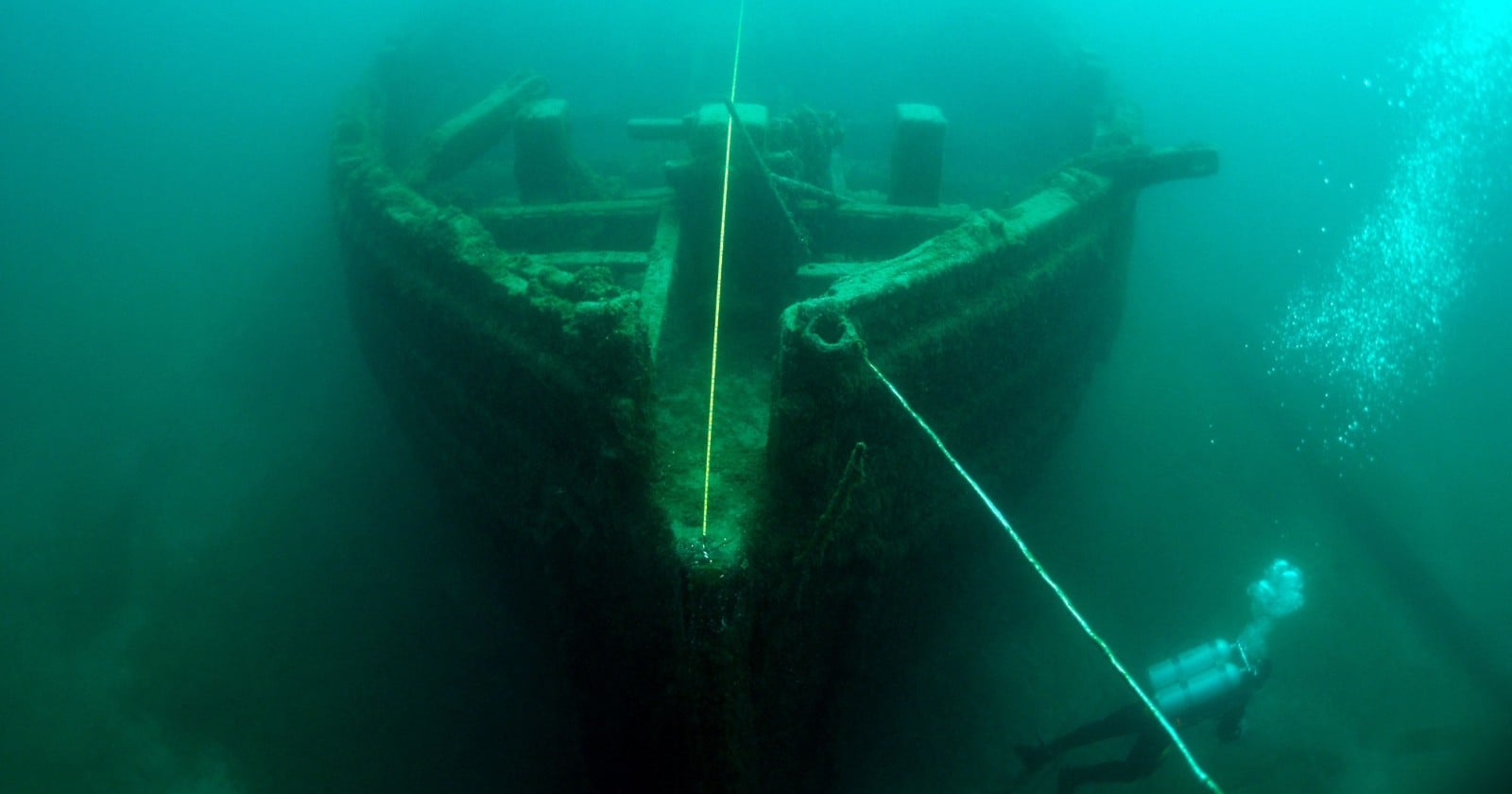
What the divers found in May 2024 is a ship taken apart by a century and a half of ice and wave action on a shallow reef. The vessel lies in 8 to 20 feet of water, bow pointed at the shoal, on a heading of 82 degrees.
A bilge fragment of the lower hull, 95 feet long and 20 feet at its widest, carried the survey baseline. The keelson runs from zero to 70 feet along it, with sister keelsons on both sides and a centerboard slot offset to port.
Three steps are cut into the keelson assembly at 8, 13 and 52 feet, each two feet long. The report says the fragment is degraded enough that it is difficult to determine whether they held masts or deck stanchions.
The stempost and deadwood, separated from the keel and still carrying three cant frames, lie 180 feet west-southwest of that. Two more hull sections sit 165 feet to the south-southeast, the larger of them 79 feet long, laid on its outer planking with the frames facing up.
That larger piece is where the ship’s working life is most legible. There is evidence of multiple repairs, with up to three, four and five futtocks per frame set, and a metal-framed lumber port thick with quagga mussels.
Running along the ceiling planking from 21 to 42 feet along that piece is part of the wooden hogging truss, the internal arch that kept a long wooden hull from drooping at the ends.
The archaeologists make the case that the breakage is the opportunity. A shattered hull exposes stem construction, inner framing and hidden workings like the hogging arch, all of which are hidden in more intact vessels. Many divers do not see it that way, since a broken hull holds less appeal than a more intact one, and between that and the remote location the report records the site as infrequently visited.
The register’s verdict on the site
The survey had a second objective, to document the features of early Great Lakes bulk-cargo sailing vessels, and the report records that one as unmet too. The reason it gives, though, is a register verdict rather than a documentation failure: the Newman’s hull is broken, with at best less than 50 percent of it located during the survey, and that lack of archaeological integrity has excluded the site from listing on the State and National Registers of Historic Places.
The paragraph immediately before it says a considerable amount of the hull components is extant, and calls the site an excellent location to study and observe the construction techniques used to build nineteenth-century Great Lakes schooners. The report puts the two statements a paragraph apart and leaves the tension in.
No state mooring buoy is planned because the site is somewhat remote and lightly dived. It sits more than five miles offshore and is easily reached by boat, but the report advises diving it only in the best conditions, without risk of being caught out in the weather that can blow up on Green Bay in the summer months.
The family that put it back on the map
The people who reported the wreck appear in the site description and in the acknowledgements. Tim Wollak and his 6-year-old daughter Henley came across fragments of it on a father-daughter fishing trip in August 2023.
He noticed the shape on his fish finder, and by the Society’s account his daughter’s first theory was a rare Green Bay octopus while his own was that he had relocated the wreck of the Erie L. Hackley. He saved a screenshot of his GPS, which is what let the archaeologists find the site again, and posted the images that October.
A Wisconsin DNR conservation warden ran out to the coordinates and captured the first footage of the wreck with a remotely operated vehicle. Henley was presented with an award at her school in Peshtigo on 29 April 2024.
The nameboards are still missing, and the case for the name is stated rather than shown: a match of dimensions the report asserts but never shows, a position, and a comparison of the vessel losses recorded in the vicinity by historic newspaper accounts.
What the state has instead is a site set up to be monitored. The 2024 tape measurements sit on file as the baseline the next survey will be read against, and the coordinates are now on Wisconsin’s Lake Michigan State Water Trail and Public Access Lands maps, more than five miles out, in eight to twenty feet of water.