
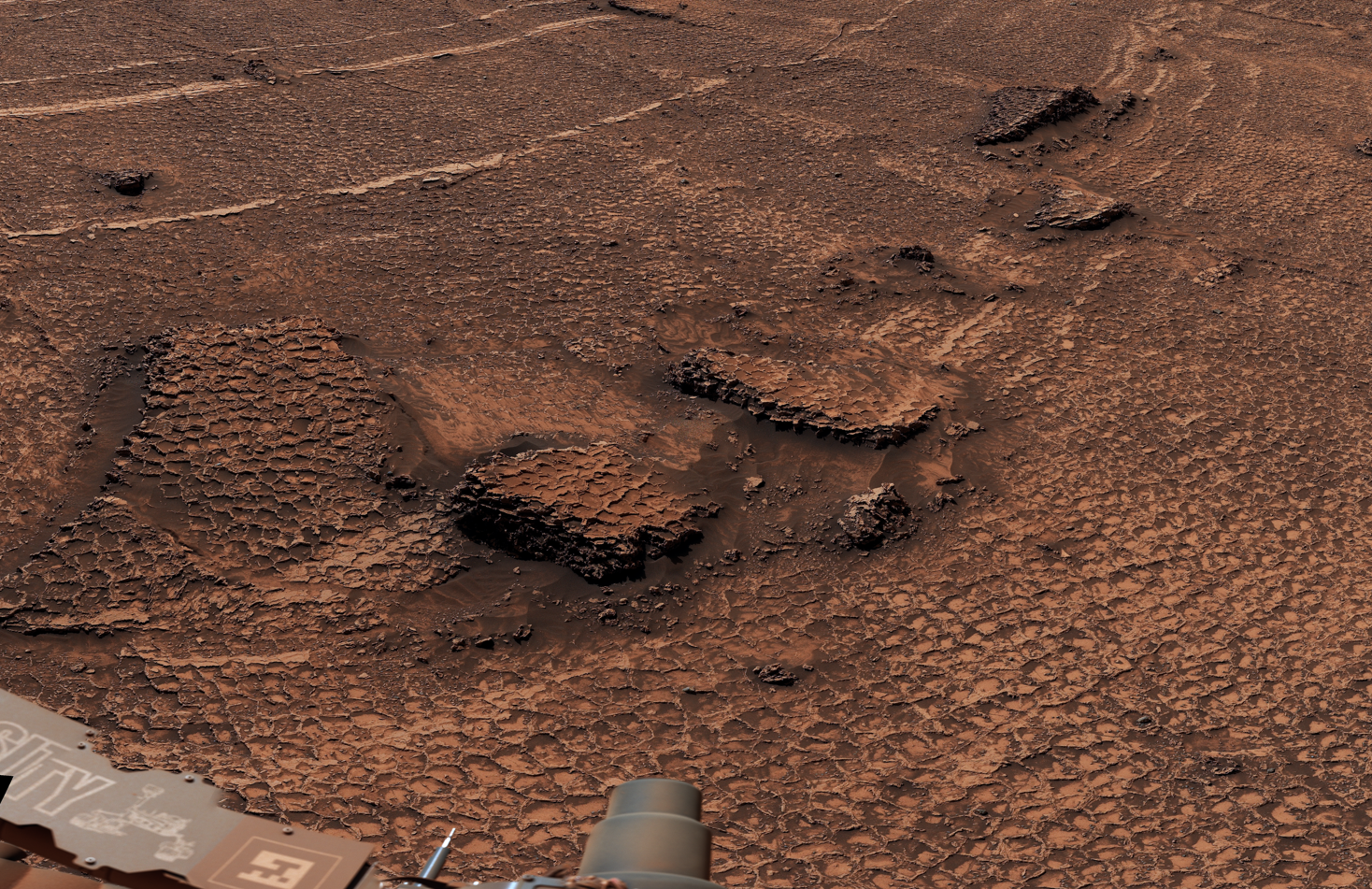
From orbit, the ground ahead of Curiosity looked light-toned and fairly smooth. When the rover drove onto it in June 2026, that broad description dissolved into thousands of small cells. Ridges divided the rock from horizon to foreground, ran around eroded slabs and continued towards a sand-capped butte. The mission team had entered what one of its members called “the top of a giant Martian honeycomb”.
It is the largest concentration of polygons Curiosity has encountered during 14 years on Mars. That is an observation about scale, not yet a conclusion about origin. Some Martian polygons are preserved mud cracks. The new field may be, too. But in its 29 July 2026 photojournal, NASA carefully kept several other explanations open: temperature cycles, compaction after burial, sediment shrinking as it lost water, and mineral changes that altered the rock’s volume.
That restraint matters. Polygonal ground looks familiar because it appears in dried lake beds and muddy puddles on Earth. Yet a familiar shape can be the end product of very different histories. The work now is to move from resemblance to mechanism.
A panorama assembled from 340 pieces
Curiosity recorded the field with its Mast Camera, or Mastcam, on 19 and 20 June 2026. Those were sols 4,930 and 4,931 of the Mars Science Laboratory mission. Engineers and imaging specialists on Earth stitched 340 separate frames into a 360-degree panorama, then balanced the colour to approximate how the terrain would look under daytime illumination on Earth.
Across the centre of the scene, most polygon cells are only about 5 to 10 centimetres wide. They are not great tectonic plates in miniature. They are hand-sized compartments in sedimentary rock, outlined by narrow raised edges. The pattern wraps around a small sand-capped butte nicknamed Miraflores and continues far beyond the closer crop NASA released to show its honeycomb texture.
The word “field” is therefore literal. Curiosity had photographed polygons before, but NASA says it had never found so many in one place. The view gives researchers something that an isolated patch cannot: repeated geometry across changes in slope, erosion and exposure.
There is also a useful lesson in the failed orbital impression. A unit that looked smooth at orbital resolution turned out to be densely structured at rover scale. Mars is mapped globally from above, but a camera standing less than two metres off the ground can still reveal the surface as something else entirely.
What a polygon is, and what it is not
A polygonal pattern usually records a material responding to stress. If a broad sheet of mud, sediment or rock contracts, it cannot always shrink as one piece. Cracks divide it into smaller cells and release the accumulating strain. Once several cracks grow and meet, a network of three-, four-, five- or six-sided compartments can emerge.
Drying mud provides the intuitive example. Water leaves the sediment, its volume falls and its surface breaks. But cooling can also make material contract. Burial can compact sediment and generate or reactivate fractures. Water can be lost from hydrated minerals without an open puddle ever existing at the surface. A chemical reaction can replace one mineral with another of a different volume. Later groundwater can fill pre-existing cracks with cement.
These processes can overlap. A crack may begin during drying, be reopened during burial and later fill with minerals carried by subsurface water. Wind can then remove the softer host rock until the tougher filling stands proud. By the time Curiosity arrives billions of years later, the feature being measured is not simply a crack. It is the surviving result of formation, alteration, burial, exhumation and erosion.
This is why the new panorama does not prove that a lake repeatedly vanished here. Geometry narrows the possibilities, but it does not by itself identify the water history.
The older Gale Crater polygons really do preserve wet and dry cycles
The comparison in the title comes from another Curiosity site called Pontours, lower in the Mount Sharp succession. In 2021, the rover photographed centimetre-scale polygonal ridges at the transition between clay-rich rock and overlying sulphate-bearing strata. Those rocks belong to the Noachian–Hesperian transition, a major interval in Mars’s environmental history about 3.8 to 3.6 billion years ago.
A team led by William Rapin reported the site in Nature in August 2023. Its case did not rest on the fact that the cells looked like mud cracks. The ridges were enriched in calcium and magnesium sulphates, and the cracks met in characteristic Y-shaped junctions. Their centimetre scale, chemistry, stratigraphic position and intersection geometry all had to agree.
Fresh mud cracks often begin with T-shaped intersections, where a new crack runs into an older one at close to a right angle. When the surface is gently rehydrated and dries again, repeated cycles can reorganise and soften the network. Junctions trend towards three arms meeting at roughly equal angles, producing the Y-shaped pattern Curiosity observed. Salty water can move through the openings, leaving minerals behind. Much later, erosion removes the surrounding mudstone more quickly and turns the filled cracks into ridges.
NASA’s image record of the Pontours mosaic describes it as the first evidence on Mars of wet-dry cycles sustained over many years. Rapin and his colleagues went further, arguing that the cycles were regular and perhaps seasonal rather than isolated consequences of an impact or volcanic episode.
The date needs one qualification. Curiosity did not watch mud dry 3.8 billion years ago, and the cracks do not carry a stamped year. They occur within strata associated with the roughly 3.8-to-3.6-billion-year-old transition from clay-bearing to sulphate-bearing environments. The title compresses that geological interval into its older boundary; the body of evidence is more accurately described as a record from that transition.
Why repeated drying interests origins-of-life researchers
Long-lived water is useful for sustaining life, but the chemistry that might precede life can face a different problem. Molecules need water to move, mix and react. If they remain too dilute, however, building longer chains becomes difficult. Alternating wet and dry conditions can repeatedly concentrate ingredients and then return them to a mobile solution.
The 2023 authors therefore noted that such cycling can promote prebiotic polymerisation in laboratory and terrestrial settings. They did not claim that the Pontours cracks contained life or that the cycles inevitably created it. They identified an environmental process that could have been chemically useful.
That boundary is familiar in Curiosity reporting. Space Daily recently covered the rover’s first tentative detection of a nitrogen heterocycle on the Martian surface. That molecule belongs to a class relevant to pathways towards RNA and DNA, but its presence is not a biosignature. In both cases, the scientifically interesting claim concerns available chemistry and environment, not evidence that biology completed the next step.
The new sea of polygons should be handled with the same discipline. Even a future identification of repeated wet-dry cycles would establish conditions and process, not inhabitants.
Curiosity is comparing the ridges with their centres
The rover team did not stop at the panorama. In a mission update published on 1 July, Space Science Institute researcher William Farrand described close inspections of both polygon ridges and polygon centres.
MAHLI, the hand-lens camera on Curiosity’s robotic arm, recorded close textures. The Alpha Particle X-ray Spectrometer, or APXS, measured elemental composition at contact range. ChemCam fired its laser at two ridges and a centre, reading the light from the resulting plasma to compare their chemistry. Its Remote Micro-Imager also examined nearby landforms.
Those comparisons can test whether the raised boundaries are simply weathered edges of the same material or chemically distinct crack fillings. A systematic enrichment along ridges could indicate that fluids moved through open fractures or that minerals grew there. Similar ridge and centre chemistry would not by itself prove a thermal origin, but it would weaken some versions of the cement-filled crack story.
Researchers can also measure cell dimensions, junction angles, ridge widths, orientation and relationships to bedding. Do the cracks stop at a layer boundary or cut through several beds? Do their sizes remain regular across the field? Are they concentrated on surfaces that once lay exposed, or do they extend through a buried deposit? Each answer removes some plausible histories and strengthens others.
These are examples of the clues the instruments can provide, not a preview of a conclusion NASA has already reached. The agency’s public description says the characteristics are still being measured so the team can “home in on which process formed them”.
The landscape contains another unresolved puzzle
The honeycomb is not the only surprise in this light-toned unit. Dark pebbles and cobbles are scattered across it. Some may have rolled down from higher layers of Mount Sharp. Some could be ejecta thrown into Gale Crater by distant impacts. Others may be meteorites that arrived from beyond Mars.
Farrand noted that earlier dark float rocks contained nickel, an element common in many meteorites but less abundant in typical Martian surface rocks. That does not make every dark stone in the new field a meteorite. Curiosity examined one of the cobbles, Cortadera, with APXS, MAHLI and ChemCam precisely because visual similarity is not enough there either.
The two puzzles share a method. A honeycomb texture does not automatically mean dried mud, just as a dark cobble does not automatically mean a rock from space. Shape and colour identify candidates. Composition and geological context do the harder work.
A cross-section through a changing planet
Curiosity is making these observations while ascending the foothills of Mount Sharp, the 5-kilometre mountain rising from the centre of Gale Crater. The rover reached the mountain in 2014 and has since travelled upwards through a layered environmental archive. Lower clay-bearing rocks formed in conditions with prolonged water. Higher sulphate-bearing terrain records a generally drier chapter, though not a simple switch from lake to desert on one particular day.
Space Daily’s earlier overview of Mars’s rivers, long-lived lakes and possible northern ocean dealt with that larger planetary picture. Curiosity contributes something more local and finely layered: not merely whether ancient Mars had water, but how often it arrived, how long it remained and how the environment shifted as the planet lost its warmer, wetter conditions.
Repeated wet-dry cracks would speak to cadence. Compaction fractures would speak to burial. Mineral-change fractures would record later alteration. Thermal contraction would describe the stresses imposed after deposition. The same field can therefore answer very different questions depending on which origin survives the measurements.
The rover’s longevity makes that stratigraphic reading possible. A machine designed for a prime mission of about two Earth years is still climbing in its fourteenth. Space Daily has previously looked at the damage to Curiosity’s aluminium wheels and the painstaking planning behind every metre. The polygon field is one return on that patience: it was not visible in useful detail until the rover physically reached it.
The most useful answer may not be the wettest one
The temptation is to promote every fractured Martian surface into a lost lake bed. Mars really did possess rivers and lakes, and Curiosity has documented them with sedimentology, mineralogy and chemistry. That established history does not make water the default explanation for every later pattern.
If the new field proves to preserve repeated wetting and drying, its scale could extend the Pontours story across another part of Mount Sharp’s record. It might show that cyclic surface water persisted more broadly, or at a different stratigraphic level, than previously recognised. That would be a substantial result.
If the ridges instead formed through thermal contraction, burial compaction or mineral alteration, the field would still be valuable. It would reveal how sedimentary rock responded after deposition and show why polygon shape alone can mislead even when a watery precedent lies elsewhere in the same crater.
For now, NASA has published an unusually clear image and an appropriately unfinished interpretation. Curiosity has found a sea of polygons. It has not yet found the single process that made it. The distinction is not a weakness in the discovery; it is the scientific question the field has placed under the rover’s wheels.