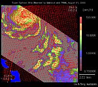
As super Typhoon Bilis, equal in strength to a category 5 hurricane, bears down on Taiwan, images taken by two NASA instruments on August 21, 2000, show the massive storm’s most devastating components: rain and wind.
Conventional satellite data provide imagery of the clouds at the top of a storm. These images, however, were created by combining data from two NASA instruments capable of looking through a storm’s clouds and seeing what is going on at the surface. These two instruments passed over the same location about one hour apart.
The images show the surface winds, measured by SeaWinds on QuikSCAT’s radar scatterometer. The wind data are superimposed on rainfall measurements made by the microwave imager on the Tropical Rain Measuring Mission satellite (TRMM).