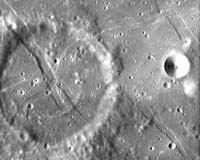
ESA’s Advanced Moon Imaging Experiment aboard its SMART-1 spacecraft has captured an image of Crater De Gasparis that shows patterns mission scientists have labeled tectonic wrinkles.
Crater De Gasparis is located close to the Mare Humorum, at longitude 51.2 degrees West and latitude 26.0 degrees South, on the lower left quarter of the Moon’s Earth-facing side. The crater has a diameter of about 30 kilometers (19 miles) and can be seen with the naked eye from Earth.
Scientists call the criss-cross patterns “rilles,” or features where the surface has sunk down to form a trench. The rilles coincide with deep tectonic faults that have been active over a long period of lunar geological evolution. They are the result of stresses such as gravitational tidal forces and volcanic expansion over the lunar mantle during the last stages of lava flooding of Oceanus Procellarum.
The fact that the rilles cross the crater means they formed after the crater. This is a good example for how geologists can determine the relative history of the Moon’s surface.
The AMIE camera obtained the image on Jan. 14 from a distance of about 1090 kilometers with a ground resolution of approximately 100 meters per pixel.
This crater is named after the Italian astronomer Annibale de Gasparis (1819-1892). De Gasparis was director of the observatory in Naples, Italy.