
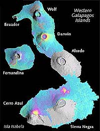
The likely answer, according to the Oct. 26 Nature study, is the “accumulation of magma in reservoirs beneath the summit calderas of each volcano.”
In addition to magma uplift, the authors suggest that an earthquake fault in Sierra Negra’s inner caldera slipped as much as 4 feet (1.2 meters) in recent years, causing the crust above the magma body “to hinge upward like a trap door.”
Overall, the Sierra Negra volcano has experienced “particularly dramatic and variable ground deformation,” write the authors.
Cerro Azul also demonstrated a great deal of activity, having risen prior to its 1998 eruption, then subsiding at least 12 inches (30 centimeters) afterward.
Of the seven volcanoes in the study, only Ecuador showed no increase in size and is therefore believed to be dormant.
Fernandina and Isabela Islands together are only about 100 miles (160 kilometers) long. That makes the Gal¿pagos the only known place on Earth with six actively rising volcanoes concentrated in such a small area.
Howard Zebker, co-author of the Nature study and a pioneer of InSAR technology, is at a loss to explain why so much volcanic uplift is occurring simultaneously.
“We don’t really understand this at all, which is what makes it exciting,” says Zebker, who holds joint professorships in geophysics and electrical engineering at Stanford.
Tortoise rescue
The 1998 Cerro Azul eruption made international headlines when the Ecuadoran army came to the rescue of giant Gal¿pagos tortoises threatened by rivers of molten lava. Because a single tortoise can weigh more than 500 pounds, army helicopters were required to airlift the endangered reptiles to safety.
In fact, neither Isabela nor Fernandina Islands has many human inhabitants. But Paul Segall, co-author of the Nature study, believes that satellite radar imagery could be used to detect volcanic activity in other areas of the world densely populated by people.
A professor of geophysics at Stanford, Segall says that thousands of lives could be saved if satellite imagery determines that supposedly “dormant” volcanoes are indeed active. He also points out that several volcanologists have been killed at Mount St. Helens in the United States and at other sites in recent years, but InSAR gives scientists the ability to track volcanoes from a safe distance.
“Our dream is to monitor all 500 to 1,000 active volcanoes on Earth using satellite radar,” notes Segall.
Jonsson, whose graduate advisers are Segall and Zebker, was born and raised in Iceland, where volcanoes are an ever-present threat.
“When I was growing up, there were nine volcanic eruptions less than 20 miles from my home,” he recalls. “I remember going to bed as a small child and seeing the bright red sky out my window.”
A typical family excursion for young Sjonni often meant driving to an erupting volcano to get a closer look. Now that he has turned his childhood fascination with volcanoes into a scientific passion, Jonsson is able to download data at a computer terminal instead of driving to the edge of a bubbling caldera half a world away.
“It’s amazing that a grad student at Stanford can learn about the Gal¿pagos without ever going there,” observes Segall.
