Orbital Imaging Corporation (OrbImage) announced today that its Internet-based OrbNet catalog of satellite-gathered Earth images is now online and available to the public. Initially, the OrbNet archive contains full-color digital data-sets of images collected by the company’s OrbView-2 satellite and processed for distribution by OrbImage personnel.
These data-sets, which are updated daily, retail for as little as $500 and are compatible with most standard image processing software packages. In the future, the OrbNet online system will also be used for the worldwide
distribution of the high-resolution (one-meter clarity) images from the company’s OrbView-3 and -4 satellites that are scheduled to be launched in 1999 and 2000, respectively.
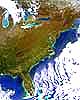
OrbView-2 is the world’s first satellite to provide daily color imagery of the Earth’s surface. OrbView-2 images are useful for such commercial applications as high-seas fishing, commercial and military maritime operations, coastal monitoring, land health assessment and agricultural yield estimation. In addition, NASA is OrbView-2’s largest customer for scientific research applications under its “SeaWiFS” program, the name given to the satellite’s on-board imaging instrument. Recently, the CBS
Evening News broadcast images of Hurricane Georges taken by OrbView-2 in its coverage of the storm hitting the U.S. Gulf Coast from Florida to Louisiana.
A basic OrbView-2 data-set comprises a coverage area of 1,500 km x 2,800 km and includes imaging information from all eight channels of the OrbView-2 imaging instrument. The basic data-sets include both “Level-1” data, which has been radiometrically calibrated for top-of-the-atmosphere distortion, and “Level-2” data, which has been atmospherically corrected
over water areas.
OrbImage Reports From Spacer.Com
EO Reports From Spacer.Com