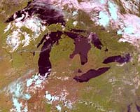
The image is from NOAA-17, which was launched on June 24 from Vandenberg Air Force Base, Calif., and named NOAA-M before launch. The image shows cloud patterns over the Great Lakes area.
Like other NOAA satellites, NOAA-17 will collect meteorological data and transmit the information to users around the world to enhance weather forecasting. In the United States, the data will be used primarily by NOAA’s National Weather Service for its long-range weather and climate forecasts.
NOAA-17 was built by Lockheed Martin Space Systems Co., Sunnyvale, Calif., and launched for NOAA under technical guidance and project management by NASA’s Goddard Space Flight Center.
NASA will turn operational control of the NOAA-17 spacecraft over to NOAA 21 days after launch. NASA’s comprehensive on-orbit verification period is expected to last until approximately 45 days after launch.