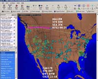
Flight Explorer, a provider of Internet-based real-time flight tracking and weather information, reporting and display products, Monday announced that, under an agreement with NAVTEQ, a global provider of digital maps for vehicle navigation and location-based solutions, Flight Explorer customers can now track the real-time location of aircraft relative to the road network of the United States and Canada and points of interest including hospitals, waterways and other relevant locations.
NAVTEQ maps offer the accuracy and reliability required to enhance Flight Explorer’s flight tracking solutions.
Using proprietary technology and collection methods, NAVTEQ field analysts collect and link the elements of the road network with its corresponding latitude and longitude.
This process, known as geocoding, results in the accurate alignment of streets, intersections, addresses and many other features with their relative locations on the earth.
With NAVTEQ maps integrated into Flight Explorer Professional – the company’s flagship product – the solution gives users a greater situational awareness of their aircraft in conjunction with other assets.
By using Flight Explorer’s proprietary interfaces and NAVTEQ maps, positional information for trucks, cargo, etc. can be displayed providing a common operating picture of all assets relative to the US and Canadian road network.
“We are seeing more and more solution providers using location information to enhance or expand their product lines. Flight Explorer recognized an opportunity to improve the robustness of their core product and turned to NAVTEQ to play a key role in this enhancement. It’s a great opportunity for both companies to bring added value to new and existing customers,” commented Winston Guillory, Senior Vice President – North American Sales.
Walt Kross, CEO of Flight Explorer, said, “NAVTEQ maps add a whole new dimension to Flight Explorer products, making them about as close to an all- in-one tool as is possible for pilots and dispatchers.”
“The map overlays will enable customers to pinpoint the location of an aircraft and other assets relative to familiar landmarks. This is a huge plus for all users, but especially helicopter operators, air medical and government organizations.”