Larry Vance, chairman and founder of Earth Search Sciences, Inc. of McCall, Idaho, today announced that the company has completed a month-long remote-sensing project over Mexico for Noranda, Inc.
This project marks the first substantial Noranda revenue contract
for ESSI and planning is presently under way for the implementation of
a Canadian program. Contract terms of the extensive project were not
released at the client’s request.
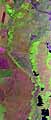
“The Mexico program demonstrated that collections in excess of
2,000 miles per day can be achieved providing rapid, large-scale
mapping capabilities,” Vance said. “The hyperspectral data collected
allows specialists access to geologic information and identifies key
minerals associated with economic mineral deposits.”
Vance founded Earth Search 15 years ago on the idea that an
advancement of existing satellite imaging technology could be
developed for use in an airplane to make more affordable and flexible
the process of scanning of the earth for minerals and other specific
targets of interest.
Probe-1 was brought to market in 1997, and in the second half of
the year conducted successful missions with U.S. government agencies
over Kazakhstan and for private clients over targets in the United
States. In the first half of 1998, the company has been at work over
target areas in Australia, Mexico and the U.S.
Earth Search officials believe Probe-1’s low-cost capabilities
extend across the mineral, environmental, defense, forestry,
agriculture and many other industries. The company is committed to
become for its clients the technological differentiator that drives
informed decision-making and reduces significantly the costs of
exploration of properties for development or other treatment.
Earth Observation Reports At SpaceDaily