The most striking discovery in recent Maya archaeology was not made by an expedition cutting through jungle with machetes, was not made by a satellite team running a new sensing pass over the Yucatán, and was not made by any of the well-funded research consortia that have been mapping the region with archaeological lidar since the 2010s. It was made by a graduate student in New Orleans, on his laptop, several years into his PhD, while clicking through unusually deep into the search results for “lidar survey Mexico” on Google. The student was Luke Auld-Thomas, a doctoral candidate in anthropology at Tulane University. The search result he found buried somewhere around page 16 was a 2013 environmental lidar survey conducted by a forest-monitoring project, originally collected to measure carbon stocks in the rainforest canopy of southeastern Mexico’s Campeche state. The data had been publicly available since 2013. It had been examined, presumably, by the project’s original environmental scientists. Nobody had thought to process it with the techniques an archaeologist would use, which strip away the tree canopy and reveal what is on the ground beneath.
According to Smithsonian Magazine’s coverage of the discovery, when Auld-Thomas ran the 2013 environmental survey through the standard archaeological processing pipeline, what emerged from underneath the rainforest canopy was a Maya political capital — a large, dense urban centre containing multiple plazas, temple pyramids, a Maya ballgame court, a freshwater reservoir, causeways connecting different districts, and more than 6,500 individual structures across the 122-square-kilometre survey area. The city had no name. It had been entirely unknown to archaeologists, entirely unknown to the Mexican government, and entirely unknown to the scientific community at large. It sat next to a regional highway. People had been farming in fields containing its ruins for years. Nobody had recognised what they were standing on. Auld-Thomas and his Tulane colleagues named the city Valeriana, after a nearby lagoon. The research was published in October 2024 in the peer-reviewed journal Antiquity.
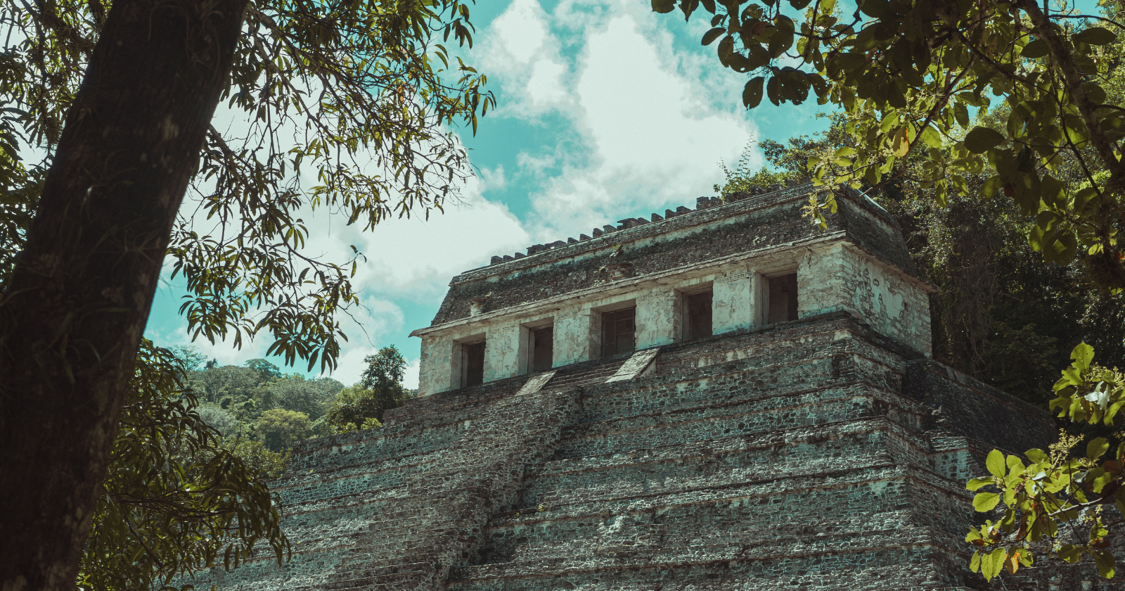
What Valeriana actually was
Per The Art Newspaper’s coverage of the Antiquity paper, Valeriana flourished during the Classic period of Maya civilisation, between approximately 250 and 900 AD, with its peak population estimated at 30,000 to 50,000 people around 750-850 AD. The city’s founding goes back substantially earlier — architectural features called E-Group assemblages, distinctive astronomical-and-ritual configurations of buildings that the Maya used to mark solstice positions, indicate that parts of Valeriana were built before 150 AD, placing the original settlement firmly in the Late Preclassic period of Mesoamerican history.
By the population standards of the ancient world, 30,000 to 50,000 residents made Valeriana a substantial city. By the standards of contemporary Campeche, which is relatively sparsely populated, it meant the ancient city contained more people than currently live in the surrounding region. The structural density of Valeriana — the second-densest known Maya settlement after Calakmul, which sits approximately 100 kilometres to the south and was previously considered the largest Maya site in ancient Latin America — strongly suggests that the city was a regional political capital. Valeriana sat at the intersection of multiple causeways, controlled access to substantial freshwater resources, and contained the monumental architecture characteristic of a Maya royal centre. The city declined and was eventually abandoned around 800-850 AD, coinciding with the broader Classic Maya collapse that depopulated much of the Yucatán Peninsula over a period of approximately a century. The most commonly cited cause is severe drought; Auld-Thomas has suggested that the densely-populated landscape had simply lost the demographic and ecological flexibility to absorb sustained climate stress.
How environmental lidar accidentally became archaeological lidar
The technical phenomenon that made Auld-Thomas’s discovery possible is one of the more remarkable methodological developments in modern archaeology. Lidar — short for “Light Detection and Ranging” — uses laser pulses fired from an aircraft to measure the distance from the aircraft to whatever is below it. The pulses return at slightly different times depending on what they hit, allowing software to construct a three-dimensional map of the surface. When the laser is pointed at a forest, most of the pulses bounce off leaves and branches, but some penetrate the canopy and reach the ground. By filtering out the canopy returns and keeping only the ground returns, archaeologists can effectively see the terrain underneath the trees — and any structures, mounds, walls, or earthworks that have been hidden by vegetation for centuries.
The technique was first applied to Maya archaeology in 2009 and produced its most dramatic early results in 2018, when the PACUNAM lidar consortium revealed more than 60,000 previously-unknown Maya structures across a 2,100-square-kilometre region of the Guatemalan Petén. Subsequent expeditions have continued to expand the known map of Maya civilisation, consistently revealing that the rainforest contained far more dense human settlement than ground surveys had ever suggested. The bottleneck on this work has been cost: archaeological lidar surveys are expensive, requiring dedicated aircraft, specialised equipment, and substantial post-processing capacity. Most archaeological projects can only afford to survey relatively small areas.
Auld-Thomas’s insight was that environmental lidar surveys — collected for forest carbon monitoring, biodiversity assessment, watershed management, or any number of non-archaeological purposes — had been quietly accumulating in publicly accessible data repositories for years. These surveys typically covered much larger areas than archaeological projects could afford, were funded by environmental agencies and conservation organisations, and had been processed only for the specific environmental purposes for which they were collected. Nobody had been systematically running them through archaeological processing pipelines. Auld-Thomas decided to try. The first promising dataset he found, on what he later described to the BBC as “something like page 16 of Google search,” was the 2013 Campeche forest survey that turned out to contain Valeriana.
What this implies about the broader Maya world
As reported by BBC News’s coverage of the discovery, the implications of the Valeriana find extend well beyond the specific city itself. The lead archaeologist on the Tulane team, Professor Marcello Canuto, framed the finding in broader civilizational terms: the discovery challenges what he called “a long-standing Western assumption that tropical regions were places ‘where civilisation went to die.'” The opposite, the recent lidar evidence suggests, is closer to the truth. The Maya rainforest contained one of the most densely populated and architecturally sophisticated urban networks anywhere in the pre-Columbian world. The Spanish conquest and subsequent reforestation hid most of this from European observers, and the assumption that the dense jungle had always been mostly empty became the default Western narrative for several centuries.
The peer-reviewed paper Auld-Thomas and his colleagues published in Antiquity, titled “Running out of empty space: environmental lidar and the crowded ancient landscape of Campeche, Mexico,” makes the more methodological argument that publicly available environmental lidar surveys contain enormous quantities of archaeological information that no one has yet examined systematically. The Valeriana discovery, in this framing, is not a one-off. It is the first major demonstration of a methodological approach that could substantially expand the known map of pre-Columbian civilisation across the Americas, and possibly across the world, with no additional data collection required. Auld-Thomas himself, in his BBC interview, noted the somewhat surreal dimension of the situation: “one of the downsides of discovering lots of new Mayan cities in the era of lidar is that there are more of them than we can ever hope to study.”
What page 16 of a Google search now contains
The Valeriana discovery has, somewhat accidentally, produced one of the more interesting case studies in modern data archaeology — the systematic re-examination of existing datasets for purposes their original collectors never anticipated. The 2013 forest survey was, by its original specification, a measurement of carbon stocks in the Campeche rainforest. Whatever the environmental scientists who collected it learned about carbon biology from those data, they presumably learned thoroughly. What they did not learn, because they had no reason to look, was that the carbon they were measuring sat on top of one of the larger pre-Columbian cities in Mesoamerica. The same data, processed differently by someone with a different question, contained a different answer.
The number of other lidar surveys sitting in environmental and conservation data repositories around the world, each potentially containing the outlines of unrecognised archaeological sites, is essentially unknown. The Tulane team is now systematically working through additional datasets. So are several other archaeological groups who have absorbed the implications of the Valeriana methodology. Whether the next decade will produce a comparable number of additional discoveries — lost cities that have been quietly mapped and quietly indexed and quietly catalogued by people who were measuring something else — is one of the more interesting open questions in current archaeology. The data are there. The question is how many people will think to look at them with a different set of eyes than the people who originally collected them. Auld-Thomas’s contribution was, in essence, that one of them now has.