The recently launched China-Brazil remote sensing satellite has a clean bill of health reports the official Chinese news agency Xinhua.
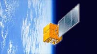
The China-Brazil Earth Resources Satellite (CBERS-1), also called Ziyuan-1 (ZY-1) in Chinese (“Ziyuan” means resource), was launched on October 14 last year from the Taiyuan Satellite Launch Center in the northern Shanxi Province.
A Long March-4B rocket placed the satellite into a polar sun-synchronous orbit of about 780 km. The satellite is controlled from the Xian Satellite Control Centre.
According to the Chinese Academy of Space Technology, the Chinese partner in the project, ZY-1 has completed all on-orbit tests and will go into operation soon.
The satellite, with a mass of 1540 kg, has a life expectancy of two years. ZY-1 completes 14 orbits each day, and repeats its ground tracks every 26 days. Since launch, ZY-1 has completed more than 1500 orbits.
This is a joint production of China and Brazil’s National Institute for Space Research (INPE) with China responsible for 70% of the cost said Chen Yiyuan, head designer of ZY-1.
Remote sensing images and data transmitted to China, Brazil and other countries will be used in resources, environment and disaster monitoring and assessment such as water quality, weather, deforestation, underground resource exploration, proper exploitation monitoring, urban planning and growth trends and production monitoring in agriculture.
ZY-1 carries three sensors:
- Wide Field Imager (WFI) with a resolution of 260 meters. The wide-angle imager scans Earth’s surface in green and near-infrared colours, and can image the entire globe in five days.
- High Resolution CCD Camera with a resolution of 20 meters in the visible spectrum. The camera can point up to 32 degrees to either side of vertical, thus it can image the surface stereoscopically. The camera can image Earth’s entire surface in 26 days.
- Infrared Multispectral Scanner (IR-MSS) with a resolution of 80 meters. The scanner operates in 4 spectral bands, including the thermal infrared. Like the CCD camera, IR-MSS covers the globe in 26 days.
The replacement of this satellite, CBERS-2, is planned for a 2001 launch.