In August 2017, the deep-sea drilling ship JOIDES Resolution dropped its drill string into the South Pacific approximately 1,500 kilometres east of Australia and began boring into the sediments at the bottom of the Tasman Sea. Over the next two months, scientists from twelve countries operating 24 hours a day across two shifts of fifteen researchers recovered approximately 2,506 metres of core from six different drilling sites scattered across an enormous submerged plateau that does not appear on most world maps. The drill pulled up sediments, then mudstones, then, in some of the cores, traces of fossilised pollen and microscopic spores from terrestrial plants that had once grown in open air. The pollen was approximately 50 to 80 million years old.
The trees and shrubs that produced it had grown on dry land that is now buried under more than a kilometre of seawater. The drilling expedition, designated IODP Expedition 371, was the first large-scale physical investigation of a landmass that geologists had spent the previous two decades arguing should be recognised as Earth’s eighth continent — and which, in February 2017, six months before the drilling expedition departed Townsville, Australia, had finally been formally recognised as such in a peer-reviewed paper in GSA Today.
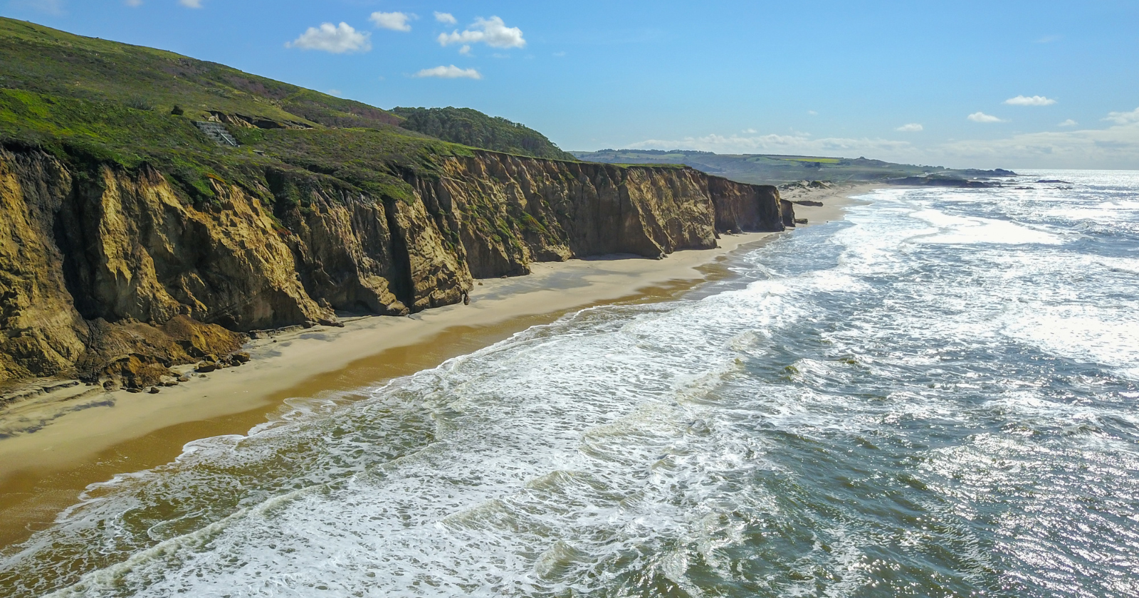
According to the GNS Science institutional reference on the discovery, the 2017 paper presented evidence that 4.9 million square kilometres of the southwest Pacific Ocean — approximately 1.9 million square miles, or two-thirds the area of Australia — is underlain by a single, coherent block of continental crust meeting all four of the standard geological criteria for continent status: elevation above the surrounding ocean floor, distinctive geology, well-defined limits and area greater than a million square kilometres, and crustal structure thicker than typical oceanic crust. The only feature distinguishing Zealandia from the seven generally recognised continents is that approximately 94 percent of it sits below sea level, in places under a kilometre or more of water. Only the islands of New Zealand, New Caledonia, and a handful of smaller islands rise above the waves. The other 94 percent has been submerged for somewhere between 25 and 80 million years, depending on which region of the continent is being measured.
What the drill cores showed
The IODP Expedition 371 cores produced one of the more startling sets of findings in recent geological research, because they showed that Zealandia’s history involves not steady submergence but a dramatic sequence of risings and sinkings tied to the broader reorganisation of the Pacific tectonic system. According to Sci.News coverage of subsequent analyses of the 2017 cores, the sediment record showed that between approximately 50 million and 35 million years ago, portions of northern Zealandia rose 1 to 2 kilometres above sea level — high enough to support forests, lakes, and a substantial terrestrial ecosystem — while other portions of the same continent subsided by approximately the same amount over the same period. After this dramatic vertical reorganisation, essentially the entire continent then sank an additional kilometre underwater, reaching something close to its present submerged state by approximately 25 million years ago.
The timing of these movements is striking because it coincides almost exactly with the formation of the Pacific Ring of Fire — the seismically active belt of subduction zones and volcanoes that today encircles much of the western Pacific. The same 50-to-35-million-year window saw the bend in the Emperor-Hawaii seamount chain, the reorientation of multiple mid-ocean ridges, and the initiation of subduction along what is now the western Pacific margin. The Zealandia core data suggest that the same massive tectonic reorganisation that created the Ring of Fire also reactivated ancient fault systems across the previously stable continental block of Zealandia, fracturing it, lifting parts of it skyward and dropping other parts beneath the sea. The continent that emerged from this process is the one geologists have now formally recognised, but at the time of the upheaval it would have been visible from low Earth orbit as a vast and dramatically restructured landmass with mountain ranges, plains, river systems, and forests, all of which have since been submerged or eroded away.
What Zealandia looked like when it was above water
The fossil pollen and spores recovered in the IODP cores provide a window into what Zealandia’s terrestrial ecosystems contained before the submergence. The microscopic remains include pollen from southern beech trees (the genus Nothofagus, still found across New Zealand, Australia, and South America today), spores from ferns, and seeds from various flowering plants. The combination is consistent with a temperate to subtropical forest ecosystem, similar in character to the forests of present-day New Zealand and Tasmania. The presence of these terrestrial plant remains in cores drilled from the deep ocean floor is the strongest possible evidence that the rock beneath was, at the time of deposition, continental rock supporting continental ecosystems, not oceanic crust.
Before its separation from the rest of Gondwana, Zealandia formed part of a vast continental block that also included Australia, Antarctica, South America, Africa, and India. In a 2017 Newsweek interview with Gerald Dickens, the co-chief scientist of IODP Expedition 371, the breakup ran on a specific timeline: “If you go way back, about 100 million years ago, Antarctica, Australia and Zealandia were all one continent. Around 85 million years ago, Zealandia split off on its own, and for a time, the seafloor between it and Australia was spreading on either side of an ocean ridge that separated the two.” The newly-isolated continental block carried with it the same plants, the same evolutionary lineages, and presumably some of the same animal populations that had been present across Gondwana. The slow submergence of Zealandia over the following tens of millions of years gradually eliminated the terrestrial habitat. The plants that survive in New Zealand today — the kauri trees, the tree ferns, the southern beeches — are the small surviving remnant of what was once a continent-wide forest ecosystem.
Why no one stood on it for so long
The reason a 1.9-million-square-mile continent could remain unrecognised until 2017 is, partly, that continents do not declare themselves. The continental nature of a region of the Earth’s crust is determined by careful measurement of multiple geological properties — the thickness of the crust, the composition of the rocks, the gravity field, the age of the basement materials — and the data required to make this determination is collected slowly, expedition by expedition, over decades. Zealandia was not entirely unknown to geologists before 2017. According to All That’s Interesting’s review of the discovery, the geophysicist Bruce Luyendyk at the University of California, Santa Barbara had proposed the name “Zealandia” for the submerged region in 1995, on the basis that the continental crust beneath New Zealand clearly extended outward across the surrounding seafloor in a way that suggested a single coherent block rather than scattered fragments. Through the 1990s and 2000s, gravity surveys, dredge samples, sediment cores, and seismic studies progressively accumulated evidence supporting this view. The 2017 GSA Today paper, by nine GNS Science geologists and two colleagues from New Caledonia and Sydney, was not the discovery of Zealandia in any sudden sense. It was the formal declaration that the accumulated evidence had reached the threshold of sufficiency.
The continent has, since then, been mapped in unprecedented detail. A 2020 mapping effort by GNS Science produced bathymetric maps showing the shape and depth of the entire submerged landmass, along with tectonic charts revealing the patterns of faulting and crustal deformation across its area. The detailed mapping has demonstrated that Zealandia’s continental crust is unusually thin — approximately 20 kilometres compared to the 30 to 45 kilometres typical of other continents — which is part of the reason it has sunk so far below sea level. The thinness is itself a consequence of the violent extension that Zealandia underwent during its separation from Gondwana, which stretched and thinned the crust before it began to subside. The result is a continent that exists in every meaningful geological sense, that has been formally recognised as such by the discipline that studies these things, and that almost no one will ever set foot on — because most of what would have been habitable land is now hidden beneath the South Pacific, accessible only to research vessels carrying drill strings long enough to reach the rock below.