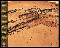
GeoFusion, Inc., a leading innovator in geospatial visualization, announces GeoPlayer Mars, created with the high performance GeoMatrix Toolkit technology. This Interactive 3D Demo allows users to interactively fly around the planet of Mars which is comprised of global imagery and terrain derived from NASA/JPL data.
Users can explore mission landing sites and the amazing craters, canyons, and volcanoes or be taken on automatic tours. This is a lower resolution version of GeoFusion’s Mars exhibit currently at the National Geographic Museum at Explorer’s Hall in Washington, D.C.
The GeoMatrix Toolkit is a C++ Software Development Kit (SDK) that provides an object oriented Application Programmer’s Interface (API) enabling software developers to build interactive full-globe geo-referenced applications.
The toolkit is a complete development environment that includes modular libraries, example applications with source code, and documentation. GeoFusion licenses the GeoMatrix Toolkit SDK for building digital Earth and other planetary visualization applications. Markets include Internet, GIS, education, entertainment, real-time terrain visualization and homeland defense.
GeoFusion’s software technology provides the engine and infrastructure for doing high performance global visualization of virtually unlimited amounts of imagery, terrain, vector, and annotation data. It provides an engine capable of displaying vast amounts of heterogeneous geospatial information which is shown in a global context while allowing for interactive zooming into complex visually stunning scenes.
It allows one to obtain a new meaning of information through innovative ways of layering, animating and blending together different types of geospatial information derived from maps, satellite & aerial imagery, terrain, annotation, and vector data. This is the same technology GeoFusion licensed to ESRI to power their new ArcGlobe product.