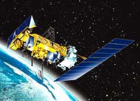
A new satellite that will improve weather forecasting and monitor environmental events around the world soared into space this morning after a picture-perfect launch from Vandenberg Air Force Base, Calif. The National Oceanic and Atmospheric Administration (NOAA)-L spacecraft, lifted off at 3:22 a.m. PDT, on an Air Force-launched Titan II rocket. Approximately 6 minutes later, the spacecraft separated from the Titan II second stage.
At approximately 4:00 a.m., PDT, controllers successfully verified deployment of the solar array and confirmed the spacecraft is in a power positive condition. NOAA-L is the second in a series of five polar-orbiting satellites with improved imaging and sounding capabilities that will operate over the next 12 years.
“We’re off to a good start,” said Harry McCain, POES program manager at NASA’s Goddard Space Flight Center, Greenbelt, Md. “The spacecraft is now in orbit and all data indicate we have a healthy spacecraft.”
NASA will turn operational control of the NOAA-L spacecraft over to NOAA in 10 days. NASA’s comprehensive on-orbit verification period is expected to take about 45 days.
The NOAA-L satellite was built by Lockheed Martin Space Systems Co., Sunnyvale, Calif., and launched for the National Oceanic and Atmospheric Administration under technical guidance and project management by the Goddard Space Flight Center.
Like other NOAA satellites, NOAA-L will collect meteorological data and transmit the information to users around the world to enhance weather forecasting. In the United States, the data will be used primarily by NOAA’s National Weather Service for its long-range weather and climate forecasts.
Data from the NOAA spacecraft are also used by researchers within NASA’s Earth Science Enterprise, a long-term research program designed to study Earth’s land, oceans, atmosphere, ice and life as a total integrated system. In addition these data are helping NASA scientists design instruments for follow-on missions.