Areas of New Orleans had been sinking for years before Hurricane Katrina flooded the city, and the worst subsidence occurred at levees that were easily breached by the storm’s surge, a study says.
“Parts of New Orleans underwent rapid subsidence in the three years before Hurricane Katrina struck in August 2005,” says the paper, published in the British science journal Nature and authored by a University of Miami team.
The evidence comes from radar images taken from 2002 to 2005 by a Canadian satellite, RADARSAT.
Carefully overlaid, the 33 images show that, overall, the city sank by an average of 5.6 millimetres (0.22 inches) a year during this time.
As global sea levels, driven by the greenhouse effect, are rising by around 2mm (0.07 inches) a year, this means the city was subsiding relative to the sea at around 8mm (0.3 inches) annually.
But the study says the subsidence is likely to have carried on over a much longer term — and some parts of the city had been sinking much faster than others.
It cited the districts of Lakeview, on the south shore of Lake Pontchartrain; Kenner, near Louis Armstrong New Orleans International Airport in east New Orleans; and regions bordering St. Bernard Parish, west of Lake Borgne.
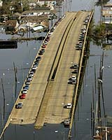
In this latter area, subsidence ran at at more than 20mm (0.8 inches) a year from 2002 to 2005, especially at the levee system along the Mississippi River-Gulf Outlet (MRGO), a canal where some of the worst breaches in flood protection occurred.
Stealthy subsidence over many years would mean that the levees could be easily topped by the storm surge without engineers being aware of the problem.
Scientists discovered after Katrina that water levels exceeded those expected for the storm by between 90cm (35 inches) and 1.7m (66 inches).
Another possibility, though, is that the subsidence promoted failure at the base of the levees, enabling the walls to be smashed aside by the surge.
As for the cause of the subsidence, the paper points the finger at the drainage of wetlands, causing highly organic soil to get dried out and compacted, although in eastern New Orleans, an active fault may have increased the problem.
Lead author is Timothy Dixon, of the University of Miami’s Rosenstiel School of Marine and Atmospheric Science.