The seas should be a safer place for ships once a new satellite system is launched to measure constantly the height of waves. A new generation of micro-satellites will reduce uncertainty about the position and location of storms by directly measuring waves from space.
It was reported today (29/9/2000) that the cruise liner Oriana was hit by a 40 foot wave which shattered windows, and injured passengers. Interviewed on the Five Live radio programme, a P&O spokesman said it was a “freak wave” that came out of nowhere.
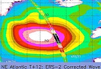
A British company, Satellite Observing Systems Ltd., expert in monitoring storms from space, has monitored a large area of rough seas moving steadily across the Atlantic over the last three days. SOS operates the Sea State Alarm, which uses satellite radar to accurately measure the waves 800km below.
Over the last three days Sea State Alarm has measured significant wave heights of more than 10 metres (30 feet) high in an area 450 km wide. Warnings are sent directly to customers and maps (see image above) are published daily on the SOS website.
SOS has teamed with world-leading builders of small satellites, Surrey Satellite Technology Ltd., to design and build a storm monitoring micro-satellite constellation called GANDER, which will tell ships at sea exactly what conditions lie ahead.
SOS General Manager, Paul Stephens said
“Ships can be caught out by severe weather because they lack accurate information, or because of an error of judgement. Meteorological computer models have difficulty predicting small violent storms because there is so little data collected at sea.
Satellites are the best way of monitoring wide expanses of ocean, but until now it has been too expensive to create an operational safety system. At last, micro-satellites are cheap enough to launch a commercially viable storm monitoring system. GANDER’s accurate wave information will give ships much more chance to avoid trouble. “
Additional Notes