Real Tour Vision has added satellite aerial views of real estate locations to their list of virtual tour features. “We are very excited to have added this new technology to our already feature-rich virtual tours,” says Jason LaVanture, Vice President of Real Tour Vision.
“It is our dedication and promise to our end users around the world to keep our virtual tours at the forefront of virtual tours technology, making the choice to choose Real Tour Vision an easy one.”
“Satellite views satisfy another piece of the puzzle for consumers who have a growing interest in on-demand visual information,” adds David Edwards, Vice President of Sales & Marketing for Real Tour Vision.
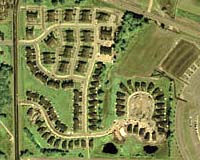
Tours with a satellite view include a “SatelliteView” navigation button on the tour window. Clicking on the button displays the satellite image in a separate window with zoom and pan functions for the image.
Viewers may also identify public landmarks (churches, schools, golf courses, parks, etc.) by making selections from a drop-down menu or choose to view a street map, topographic map or environmental map of the area. RealBird, a service of the DonationChannel, provides the satellite aerial views and maps to Real Tour Vision.
An optional service ($5/tour – viewable for up to 12 mos.), a Real Tour Vision spokesman says while many satellite views are black & white, more are being added in color, especially aerial views of larger urban areas.
In addition to the satellite view feature, Real Tour Vision has also recently added local school information from the National Center for Education Statistics and MLS (Multiple Listing Service) summary data that is displayed within each real estate tour window.
Real Tour Vision, headquartered in Traverse City, Michigan, is still selling dealerships in selected areas of the United States to produce virtual tours for Real Estate firms, Resorts, Universities, Hospitals, and many other businesses that benefit from providing an online, e-mail or disk/CD-ROM tour of properties or facilities.