Brilliantly colored strawberry poison dart frogs singing in the jungle below didn’t notice the NASA DC-8 flying laboratory passing overhead. After all, there is little disturbance to the rain forest by an aircraft far above.
The DC-8’s mission is NASA’s AirSAR 2004 campaign, a three-week Earth science expedition by an international team of scientists. Flying over the La Selva rain forest in Costa Rica, scientists aboard the flying laboratory are using an all-weather imaging tool called the Airborne Synthetic Aperture Radar (AirSAR).
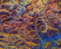
The radar, developed by NASA’s Jet Propulsion Laboratory, Pasadena, Calif., can penetrate the dense rain forest canopy and scan through clouds to produce highly accurate topographic computer models. Recently, triangular radar reflectors were set up in the La Selva jungle at precise points on the ground so that scientists aboard the aircraft could calibrate the AirSAR radar from the air. The silver, aluminized reflectors temporarily added a decidedly high-tech look to the natural surroundings in which they were placed.
AirSAR 2004 scientists are endeavoring to accurately inventory Costa Rica’s tropical rain forests and irreplaceable archaeology by characterizing past and present human impacts on them. The plan is to help prevent further loss of the country’s unique natural and cultural resources.
The DC-8 and its AirSAR sensors provide unique data not available from other space-based or commercial airborne platforms. The unique aircraft has flown hundreds of Earth science payloads such as the AirSAR, contributing to the ever-growing knowledge base of science data gleaned from the air.
NASA’s Dryden Flight Research Center, located at Edwards Air Force Base, Calif., operates the aircraft, along with two high-altitude ER-2 science platforms.
Following the rain forest radar imaging effort, the DC-8 is off to ice-covered Antarctica, where it will begin characterizing the impact of climate change on glaciers and ice shelves in the Antarctic Peninsula area which seem to be contributing to sea level rise.
AirSAR’s 2004 campaign is a collaboration of many U.S. and Central American institutions and scientists, including NASA, the National Science Foundation, the Smithsonian Institution, the National Geographic Society, Conservation International, the Organization of Tropical Studies, the Central American Commission for Environment and Development, and the Inter-American Development Bank.