The European Space Agency (ESA) announced Friday it would replace an important climate research satellite that was lost in a launch by a Russian rocket last October. The 140-million-euro (170-million-dollar) CryoSat satellite was irretrievably lost shortly after lift-off on a converted Soviet-era ballistic missile from a base in northwest Russia on October 8.
At a two-day meeting in Paris, ESA’s Earth Observation Board was given the green light to build and launch a replacement, which will be called CryoSat 2, the agency said in a statement.
The satellite is expected to be launched in March 2009.
“This decision is very important, as the scientific community in Europe and elsewhere is eagerly awaiting resumption of the CryoSat mission,” said Volker Liebig, ESA’s director of Earth observation programs.
The first CryoSat spacecraft had to be destroyed last Oct. 8, when its launch vehicle malfunctioned.
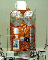
CryoSat-2 will be designed to carry out a three-year mission to monitor precisely any changes in the elevation and thickness of polar ice sheets and floating sea ice. The satellite will need to orbit at an unusually high inclination, reaching latitudes of 88 degrees North and South, ESA said in a statement.
CryoSat’s main instrument, the SAR/Interferometric Radar Altimeter, or SIRAL, is based on existing technology, but engineers will enhance the basic design to overcome some of the difficulties associated with tracking ice surfaces precisely.
For example, one of the spacecraft’s two antennas will send out radar signals, but both will detect the signal echoes from Earth’s surface.
By using highly accurate positioning data for the spacecraft – achieved with an onboard ranging instrument called a Doppler Orbitography and Radiopositioning Integrated by Satellite, or DORIS, receiver supplemented by a laser retro-reflector system – the signal return time will reveal the surface altitude. CryoSat-2 will maintain its correct antenna orientation using a trio of star trackers.
ESA also said SIRAL’s new design will provide detailed views of irregular sloping edges of land ice and non-homogenous ocean ice.