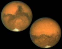
Space Imaging is releasing two images of Mars taken by its Ikonos satellite as the red planet and Earth reached their closest proximity in nearly 60,000 years. At that point which occurred last week, Mars was 34.6 million miles (55.6 million kilometers) away.
The first image (sample pictured) was taken on Aug. 26, 2003 at 21:40 GMT (3:40 p.m. MDT) as Ikonos came out of the eclipse of the Earth and orbited over our planet’s northern pole. The second image (not pictured) was taken a little more than half a Martian rotation later on Aug. 27, 2003 at 12:26 GMT (6:26 a.m. MDT). The Martian south polar ice cap is visible at the bottom of both images.
The resolution of these images is approximately 67 km. Ikonos takes images of Earth at 1-meter resolution. Although Ikonos is designed to take images of the Earth, because of its agility, it can look away from Earth and take images of objects in space.
Even though Space Imaging doesn’t sell stellar images, it does periodically take images of specific stars in order to calibrate the Ikonos imaging array for luminosity.