The domestically developed and built Fengyun-1C meteorological satellite (FY-1C, Fengyun means “Wind and Cloud”) reached an operational milestone last month, the official Xinhua News Agency reported.
The satellite passed the one year mark of operation, dutifully sending back weather images daily.
FY-1C was launched on board a Changzheng-4B rocket on May 10, 1999, from the Taiyuan Satellite Launch Centre in the northern Shanxi Province.
The sunsynchronous polar-orbiting satellite circles the Earth at an average altitude of 858.5km and completes an orbit every 102 minutes. According to the Shanghai Academy of Spaceflight Technology (formerly known as the Shanghai Bureau of Astronautics), which develops and builds the satellite, since launch FY-1C has made more than 5,200 orbits.
The satellite maintains a stable performance. Its electrical system supplies plenty of power, with sensing and thermal regulation systems operating reliably. Ren Xinmin, chairman of the performance verification committee, said, “FY-1C excels in service at the world advanced level.”
A major sensor on FY-1C is the Multichannel Visible and IR Scan Radiometer (MVISR) which has ten channels: four in visible wavebands, three in near-infrared, one in short-wave infrared, and two in long-wave infrared. The image resolution in the visible channels is 1.1km at the sub-satellite point.
In addition to the primary use in weather forecast, imagery and data transmitted, the FY-1C has assisted in forecasting and reporting sandstorms, fire and flood. For example,
- In March and April FY-1C images were used to provide accurate forecast of sandstorms in the northern part of the country.
- On March 28 the satellite reception station in Guangzhou, the capital of the southern Guangdong Province, dispatched timely information to local fire stations of the 55 wildfire locations in the province based on FY-1C images.
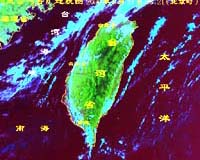
- In September last year FY-1C vividly documented the movement of Typhoon No. 14 (called Typhoon York elsewhere) which made landfall in Hong Kong and its rapid weakening inland. The tracking of the typhoon gave advance warning to residents in Hong Kong, therefore minimizing damage from the storm.
Imagery and data from FY-1C are also used in other countries, such as Britain, Singapore, Spain, Italy, U.S., France and Germany.
FY-1C is China’s first operational polar-orbiting meteorological satellite. Two previous experimental satellites, FY-1A and -1B, went into orbit in 1988 and 1990 respectively.
The National Satellite Meteorological Center (NSMC), a scientific research and operational facility affiliated to the China Meteorological Administration (CMA), receives, processes and distributes data to users.