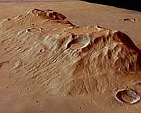
This image, taken by the High Resolution Stereo Camera on board ESA’s Mars Express spacecraft, shows the Ausonia Mensa massif on Mars. The HRSC obtained the image during orbit 506 with a ground resolution of approximately 37.6 meters (122 feet) per pixel.
The scenes show the region of Hesperia planum containing the massif, located at approximately 30.3 degrees South and 97.8 degrees East. North is to the right.
Ausonia Mensa is a large remnant mountain with several impact craters, rising above basaltic sheet layers. The mountain stretches over an area of about 98 kilometers by 48 kilometers (63 miles by 31 miles) and has an elevation of 3,700 meters (12,025 feet).
A large crater, approximately 7.5 kilometers (4.8 miles) in diameter and 870 meters (2,825 feet) deep, has been partially filled with sediment. The northern flank of the crater is broken by a large gully caused by erosion. Numerous branched channels, also resulting from erosion, run along the edge of top of the plateau toward the plains at the foot of the mountain.
The western flank is dominated by a large crater, about 6 kilometers (3.8 miles) in diameter, which clearly shows an ejecta blanket and secondary cratering. Aeolian, or wind-created, structures are visible about 50 kilometers (32 miles) to southeast of the massif, indicating channeling of atmospheric flow. They are clearly visible because of their different color.
A heavily eroded, partially filled crater approximately 6 kilometers in diameter is visible to the north of the massif. The crater is characterized by numerous, smaller and younger craters.
ESA mission scientists derived the color scenes from the three HRSC-color channels and the nadir channel. The perspective view was calculated from the digital terrain model derived from the camera’s stereo channels.