Intergraph Mapping and Geospatial Solutions Wednesday announced the latest selection of its Z/I Imaging Digital Mapping Camera (DMC) by Asia Air Survey (AAS) (Tokyo, Japan), one of the largest survey, mapping and engineering consulting firms in the world.
The DMC helps companies improve productivity by providing a complete digital workflow for data acquisition that includes mission planning, sensor management, digital imagery processing, photogrammetric software and a client/server image management, storage and distribution system.
With the acquisition of the DMC, AAS will be able to expand the map production processes performed at each of its main production bases, transforming its processes to an all-digital environment.
The DMC will provide the front end of a complete digital image production system, which includes existing CAD and GIS systems. The new workflow will not only speed up the production process with its extreme efficiency, but also will give the company the functionality required to generate three-dimensional (3D) spatial models.
With the implementation of the DMC and the transition to an all-digital production system in our production base, we look to embrace new market opportunities,” said Dr.Kazuya Saito, DMC Project Manager, Asia Air Survey.
“Thanks to the imaging quality and efficiency that the new system will bring to our organization, we can increase our work capacity and still meet our customers’ needs for high-quality products and fast turnaround times.”
Using fully digital production tools at each branch office will enable AAS to provide advanced and precise products for its customers, including 3D city models and digital true orthophotos from any of its locations. Intergraph will collaborate with Asia Air Survey. to build these systems and to ensure smooth transition to the new technology across the enterprise.
With the production base systems in place, AAS will be better equipped to produce spatial and mapping imagery that helps officials address emergency situations in urban areas. With the combination of the DMC and an airborne laser system, AAS will now be able to produce 3D spatial data and a precise digital image in less than one day.
For example, AAS will have the capability to process damage forecasts from a single photograph image if disaster strikes.
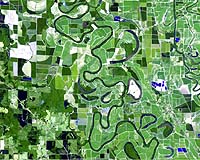
The DMC captures imagery with proven ground resolutions as small as 1 1/2 inches per pixel.
Imagery acquired with the DMC maintains its initial high geometric and radiometric quality throughout each stage of the project lifecycle – mission planning, sensor management, photogrammetric production and client/server image management, storage and distribution.
Another design feature of the DMC is its ability to collect aerial frame photography in panchromatic color and color infrared bands simultaneously. This allows three separate end products – black and white, natural color and false-color infrared – to be generated from a single airborne data set.