

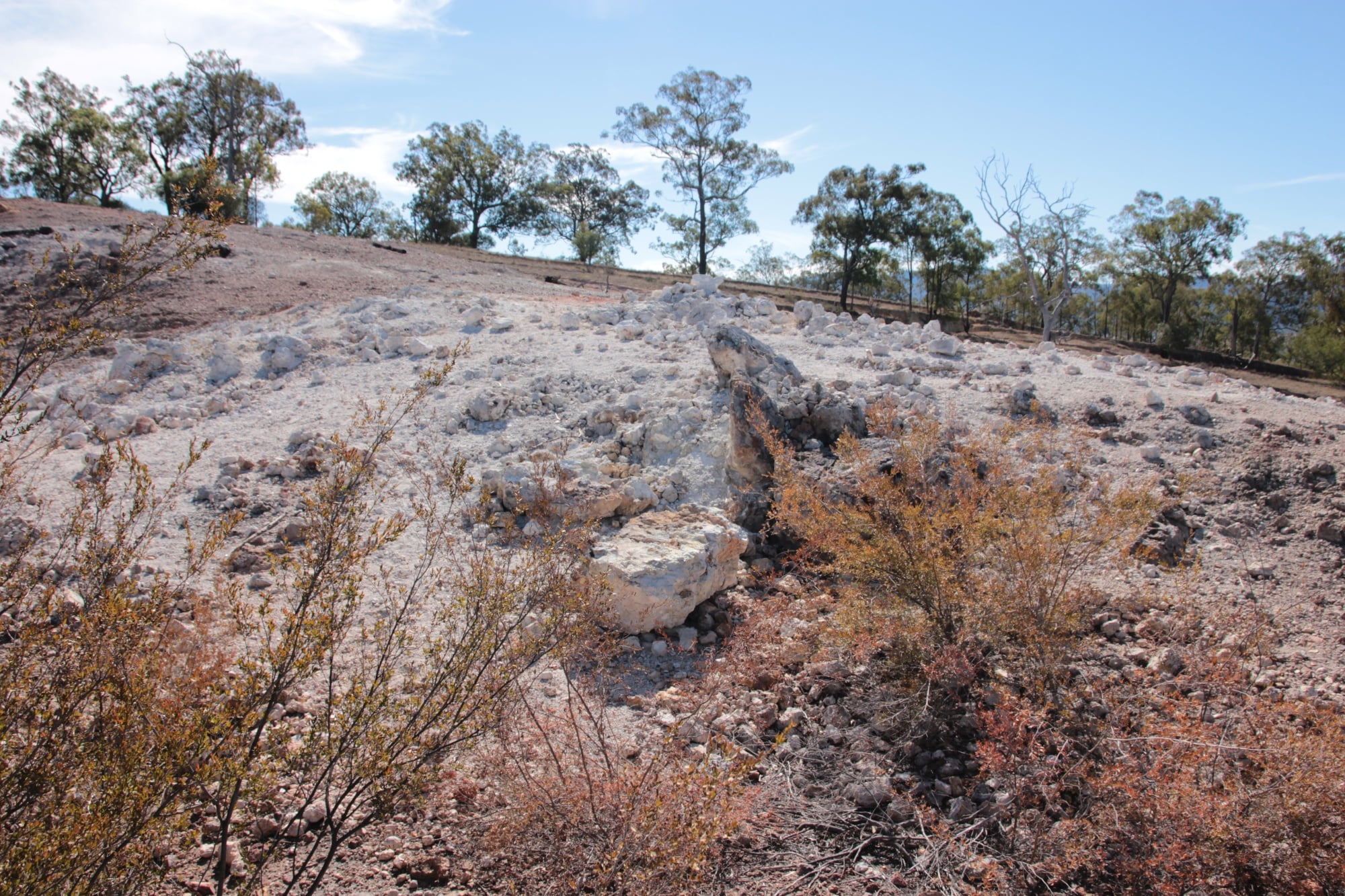
At Burning Mountain, the most important part of the landscape is out of sight. Roughly 30 metres beneath Mount Wingen in the Upper Hunter region of New South Wales, a coal seam is slowly being consumed. The surface signs are quieter: warm ground, sulphurous fumes, bleached soil, fissures and patches where vegetation struggles to return.
The NSW National Parks and Wildlife Service estimates that the fire has been burning for as much as 5,500 years and is moving south at about one metre each year. A recent geological study puts its duration at at least six millennia. This is a natural process moving slowly enough for people to walk beside it, yet fast enough to redraw the mountain over centuries.
A fire with no crater and almost no flame
Mount Wingen is not a volcano. The heat comes from a burning coal seam rather than magma rising from Earth’s mantle. Coal can smoulder without producing the open flames associated with a bushfire. Oxygen reaches the seam through cracks and porous rock, while the surrounding ground helps insulate the hot zone from rain and rapid cooling.
The active fire front lies about 20 to 30 metres below the surface. As it advances, it consumes the seam and alters nearby rock. Some material has been heated enough to form hard, ceramic-like rocks known as paralavas. Above the burned section, the ground can fracture or slump as the space once occupied by coal collapses. Those breaks also provide routes for smoke and gases to reach the air.
A 2026 study in Communications Earth & Environment examined these transformed rocks and the mineral changes created by the heat. The authors describe Mount Wingen as the oldest known continuously burning coal fire and locate the present combustion zone beneath the southern part of the site.
The surface does not look like a conventional fire ground. Visitors may see a pale, baked patch surrounded by bush, smell sulphur or catch vapour leaving a vent. The apparent stillness is deceptive. The reaction below is slow combustion, sustained within a fuel bed that extends through the mountain.
How one metre a year becomes six millennia
No one observed the fire begin. Its age is an estimate built by combining the length of the heat-affected zone with the measured speed of the active front. If combustion moves roughly one metre each year and leaves several kilometres of altered terrain behind it, the implied duration is measured in thousands of years.
That does not mean the fire has travelled at precisely the same rate in every period. Its progress depends on the thickness and quality of the coal, the availability of oxygen, the position of groundwater, and fractures in the surrounding rock. A wetter section or a break in the seam could slow it; a well-ventilated fracture could change the local rate.
The often quoted span of 5,500 to 6,000 years is therefore a reconstruction, not a direct date stamped on the first ignition. The official reserve account uses the lower estimate, while the geological literature reaches at least six millennia. The Guinness World Records listing gives Burning Mountain an estimated age of 6,000 years.
Its original ignition remains uncertain. A lightning strike, a bushfire reaching an exposed seam or spontaneous combustion have all been considered possible. What can be mapped more confidently is the trail left behind as the fire moved south and the position of the modern heat source below the reserve.
The “volcano” reported in 1828
The written colonial record begins with smoke, heat and a mistaken diagnosis. Reports reaching Sydney in 1828 described a volcano in the Liverpool Range. An account published under the heading “The Volcano” in The Australian on 30 July that year described an expedition to the smoking mountain. That historical text is preserved by Project Gutenberg Australia.
In February 1829, the clergyman and amateur geologist Charles Pleydell Neale Wilton examined the ground. He recognised that the heat came from burning coal, not volcanic activity. The correction replaced one geological explanation with another, but it did not mark the beginning of human knowledge of the place.
A study published in Aboriginal History traces the site’s connections to the Gea-Wegal clan of the Wanaruah nation and notes that Aboriginal knowledge predated the European reports. Its account shows why the wording “first documented European observers” matters. A colonial newspaper can establish when a report entered the surviving European record; it cannot establish when people first knew the mountain was warm or smoking.
The “volcano” label was understandable from a distance. Smoke emerged from the ground, vegetation was sparse around hot patches and the rocks had been visibly altered. Yet Mount Wingen lacks the magma chamber, vent and erupted material of a volcano. It is a coal deposit behaving like a very slow subterranean furnace.
Why an underground coal fire can keep going
A buried fire persists through a particular balance of fuel, insulation and oxygen. Too little oxygen and combustion stops. A limited supply through fractures can sustain smouldering, while the surrounding rock retains heat. Because the fuel is underground, rain cannot simply soak the whole combustion front.
Extinguishing a coal-seam fire is difficult even when its position is known. Flooding, excavation and sealing may work in some settings, but each method is constrained by geology. Water can drain away before cooling the full hot zone. Excavation can expose fresh coal or admit more oxygen. Sealing every pathway becomes difficult when fractures cross a large, irregular body of rock.
There are modern examples of the same persistence, though not on Mount Wingen’s timescale. At Centralia in Pennsylvania, a coal fire has burned beneath former mine workings since 1962. Mount Wingen differs in age, geological setting and probable cause, but both places demonstrate how an underground fuel source can remain active after the air above it appears clear.
At Burning Mountain, the advance is not the mountain itself sliding south. It is the combustion front finding new coal. Behind it lie baked rocks and a surface that has adjusted to the loss of material below. Ahead lies unburned seam. At about one metre a year, a person could return after a decade and find the hottest zone roughly ten metres farther along.
A walking track beside a moving geological process
Burning Mountain Nature Reserve is now reached by a formed walking track. The NSW Government describes the walk as a four-kilometre return route with information panels and a viewing platform near the active area. Conditions vary, so smoke or strong odours are not guaranteed on every visit.
The track is also a safety boundary. Heat can destabilise the ground, and fissures or slumping may occur where the seam has burned below. Visitors are told to remain on the formed route. This protects the reserve and keeps people away from ground whose apparently solid surface may conceal heat or voids.
The label “continuously burning” needs one final qualification. It does not describe an unchanged flame witnessed across 6,000 years. It describes a migrating underground combustion process reconstructed from its long trail of altered rock, surface features and current movement. The age is estimated, the rate can vary and the ignition cause is not settled.
Those cautions make the story more precise, not less remarkable. Beneath a quiet Australian hillside, a fire probably lit before the Great Pyramid of Giza was completed is still consuming its way through coal. It moves south at roughly the pace of a long human stride each year, leaving a geological record behind it and a few wisps of smoke above.