
For many people, the geomagnetic storm of November 2025 was a night of rare auroras. For a network of fixed satellite-navigation receivers, it was something less photogenic and more consequential: calculated positions abruptly shifted by more than 10 metres in parts of the continental United States.
The disruption was not confined to the far north, where space-weather interference is familiar. Strong fluctuations in GPS signal strength appeared across a broad band of the country, while the ionospheric disturbance associated with them stretched nearly from one coast to the other. Researchers say amplitude scintillation this widespread had not previously been documented at American mid-latitudes.
The storm arrived in November, outside the spring planting period when centimetre-level satellite guidance is most heavily used across the agricultural Midwest. That fortunate timing limits what can honestly be said about its economic effect. The study did not calculate hundreds of millions of dollars in actual November farm losses. Instead, it showed that a disturbance capable of disrupting precision agriculture crossed the country, and pointed to the estimated half-billion-dollar consequences of a different storm that struck during planting in May 2024.
The storm behind the aurora
The chain began in active region 14274 on the Sun. A succession of X-class flares and coronal mass ejections erupted in early November 2025. The strongest flare, rated X5.1, peaked at 10:04 UTC on 11 November. Several clouds of magnetised solar plasma then interacted on their way towards Earth and drove a major disturbance in the planet’s magnetic environment.
The US Geological Survey recorded the storm’s sudden commencement at 19:10 Eastern time on 11 November. NOAA’s Space Weather Prediction Center classified it as G4, or severe, on the agency’s five-level geomagnetic-storm scale. “Superstorm” is the terminology used by the research team and in the paper’s title; it should not be mistaken for a separate NOAA category or silently upgraded to G5.
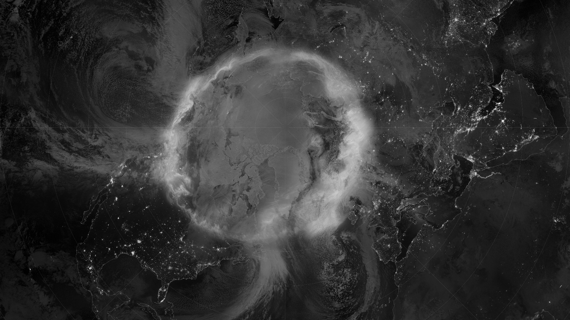
The visible result was an auroral oval pushed unusually far towards the equator, with reports from locations as far south as Florida. The less visible result was a deeply disturbed ionosphere, the electrically charged region of the upper atmosphere through which radio signals from navigation satellites must pass.
SpaceDaily’s first account of the November flare sequence described researchers beginning to unpack its effects only days after the storm. The new analysis turns that broad warning into a detailed map of where navigation signals deteriorated.
How a storm moves a calculated position
GPS determines position by comparing the arrival times of radio signals transmitted by satellites whose orbits and clocks are known. The satellites did not suddenly move ten metres. The path between transmitter and receiver changed.
A radio wave slows and bends slightly as it crosses the ionosphere. Under ordinary conditions, receivers and augmentation systems can estimate much of that delay. During a geomagnetic storm, however, the ionosphere can develop steep electron-density gradients and irregular structures that change rapidly across both distance and time.
Signals passing through that uneven plasma can fluctuate in amplitude and phase, a phenomenon known as scintillation. Mild scintillation adds noise. Strong scintillation can cause a receiver to lose its lock on a satellite’s carrier signal, miscount cycles or temporarily reject observations. The position solution then becomes poorer precisely when a high-accuracy user needs it to remain stable.
Scintillation is not new. It is common in equatorial regions and at high latitudes. The surprise in November was its scale across mid-latitude North America, an area often treated as comparatively quiet.
What the researchers measured
Endawoke Yizengaw of The Aerospace Corporation led the study with colleagues from several institutions. Their paper, published in Geophysical Research Letters on 29 August 2026, combined auroral imagery with measurements from ground-based Global Navigation Satellite System receivers across the United States and Canada.
The team reconstructed electron content, density gradients, signal scintillation and horizontal positioning errors as the storm developed. It found a broad east-west region of auroral activity and enhanced particle precipitation. Along that region, sharp changes in electron density encouraged smaller plasma irregularities to form.
Strong amplitude scintillation appeared over a wide longitude range, roughly 80 to 120 degrees west in the maps highlighted by the researchers. Related ionospheric structures extended farther, producing the near coast-to-coast description. Those two claims are connected but not identical: the most clearly mapped band of strong signal flickering did not cover every kilometre from the Pacific shore to the Atlantic shore.
At the same time, horizontal GPS position errors exceeded 10 metres in some locations. That figure is a threshold reached in parts of the network, not a statement that every receiver in the United States was misplaced by the same amount for the whole storm.
The timing between brighter auroral activity, stronger density irregularities, increasing scintillation and degrading positions helped the authors link the effects. A network of fixed scientific receivers was especially useful because their true locations were already well constrained. When a stationary instrument’s calculated position moves, the error can be measured directly.
Why a ten-metre error matters on a farm
A phone giving road directions can often tolerate several metres of error. Its software can place the user on the nearest road and combine GPS with other sensors. Precision agriculture is built around a much tighter requirement.
Modern tractors use corrected GNSS guidance to follow repeatable paths with centimetre-level accuracy. That allows a planter to place rows cleanly, reduces overlap in fertiliser and chemical application, supports controlled traffic and records where seed varieties or treatments were applied. Accuracy is part of the production system, not merely a convenience for the driver.
A ten-metre displacement is wider than many pieces of farm machinery and vastly larger than the intended spacing between passes. A system may respond by steering off line, generating alarms or refusing to engage automatic guidance. Continuing to plant can create gaps and overlaps; stopping can consume a narrow window when soil moisture and weather are suitable.
High-precision users also depend on corrections from reference stations or satellite services. Those corrections work best when the rover and reference experience sufficiently similar signal errors. A storm can create gradients that vary too sharply for a correction measured elsewhere to describe conditions at the machine.
The half-billion-dollar comparison
The warning about agricultural losses comes mainly from what happened during the May 2024 Gannon storm. That event reached G5, the highest NOAA category, and struck while farmers across major corn-growing states were planting. GPS-guided equipment veered from its intended paths or lost high-precision service, forcing some operators to pause.
Kansas State University agricultural economist Terry Griffin estimated the resulting loss in potential profit at roughly $500 million, with later university material citing an assumed total near $565 million for Midwestern crop producers. His economic assessment considered delayed field work, planting-date yield penalties, adoption of satellite guidance and the number of affected acres. It was not an audited invoice for physical damage.
That qualification matters. Weather, local planting progress, receiver type, correction service and a farm’s ability to recover lost time all influence the eventual cost. The figure nevertheless gives a defensible order of magnitude for what a widespread navigation outage can mean when it arrives at the worst point in the agricultural calendar.
As SpaceDaily recently examined in detail, the Gannon storm also compressed the plasmasphere, expanded auroral ovals and disturbed several layers of the near-Earth environment. Its tractor failures were one surface expression of a much larger coupled event.
The November 2025 study does not prove that an identical $500 million loss would have occurred in spring. The storm was different, the geographic pattern was different and the response of particular farm systems was not tested. What it establishes is the missing physical premise: navigation errors large enough to disrupt precision operations spread across regions where such intense amplitude scintillation was not expected.
Why the near coast-to-coast reach is the important result
Space-weather risk has often been organised around familiar zones. Operators expect auroral disturbances at high latitudes and equatorial plasma bubbles at low latitudes. Mid-latitudes appear safer in ordinary conditions, so infrastructure and warning assumptions may give them less attention.
During the November storm, the auroral oval migrated towards the equator. Energetic electrons followed magnetic field lines into the upper atmosphere across a wide span of longitudes. Their collisions changed ionisation, while storm-enhanced density structures approached from lower latitudes. The continental United States became the meeting ground for processes normally associated with different regions.
The result was not a smooth blanket of error. It was a changing field of steep gradients and smaller irregularities, with the strongest effects moving as the aurora and ionosphere evolved. That spatial complexity helps explain why a single warning such as “GPS may be degraded” is operationally incomplete. A user needs to know where, when, by how much and for how long.
What resilience would look like
No single upgrade makes precise positioning immune to space weather. Dual- and multi-frequency receivers can estimate ordinary ionospheric delay more effectively than single-frequency units, but severe scintillation can still break signal tracking. More reference stations improve local correction coverage, but rapidly changing gradients can reduce how far any correction remains valid.
Resilience therefore has to be layered. Receivers can monitor signal quality and reject corrupted measurements. Machinery can combine satellite navigation with inertial sensors, cameras or other local references. Operators can receive clearer space-weather alerts, pause the most accuracy-sensitive work and retain a safe manual mode when automated guidance becomes unreliable.
Forecasting remains a difficult part of that system. Scientists can observe an eruption leaving the Sun, but the magnetic orientation that controls how efficiently it couples with Earth may remain uncertain until spacecraft sample the approaching solar wind much closer to the planet. The new study argues for coordinated observations and physics-based modelling capable of following auroral precipitation, density gradients and irregularities as they develop.
The National Science Foundation is also supporting work that uses fixed GNSS networks to understand positioning failures and explore better prediction. Such networks were built largely for geodesy and studies of Earth’s crust, yet their stable coordinates make them valuable monitors of the changing sky above them.
A warning made visible after the event
November 2025 did not produce a documented planting disaster because there was little spring planting to interrupt. That should not be presented as proof that the storm was harmless, nor should a May 2024 cost estimate be relabelled as a November loss.
The more careful conclusion is still serious. A G4 storm drove strong radio-signal scintillation into mid-latitude regions across much of the continental United States, and fixed receivers recorded errors exceeding 10 metres. The event exposed a geographic reach that ordinary risk assumptions did not capture.
The aurora made the storm beautiful enough to photograph. The receiver network revealed the less visible part: infrastructure on the ground can lose precision because the atmosphere hundreds of kilometres overhead has become electrically uneven. Had that same alignment of wide disruption and vulnerable technology occurred during a narrow planting window, the colour in the sky could have carried a price measured in hundreds of millions of dollars.