Hurricane Marie is spinning far out in the Pacific while its swell is already breaking on Southern California beaches, KTLA 5 reports, with the surf arriving days ahead of a storm that never comes ashore
The Pacific's most powerful storms can reshape coastlines from hundreds of miles away, delivering dangerous surf long before—or even if—the hurricane itself never arrives.
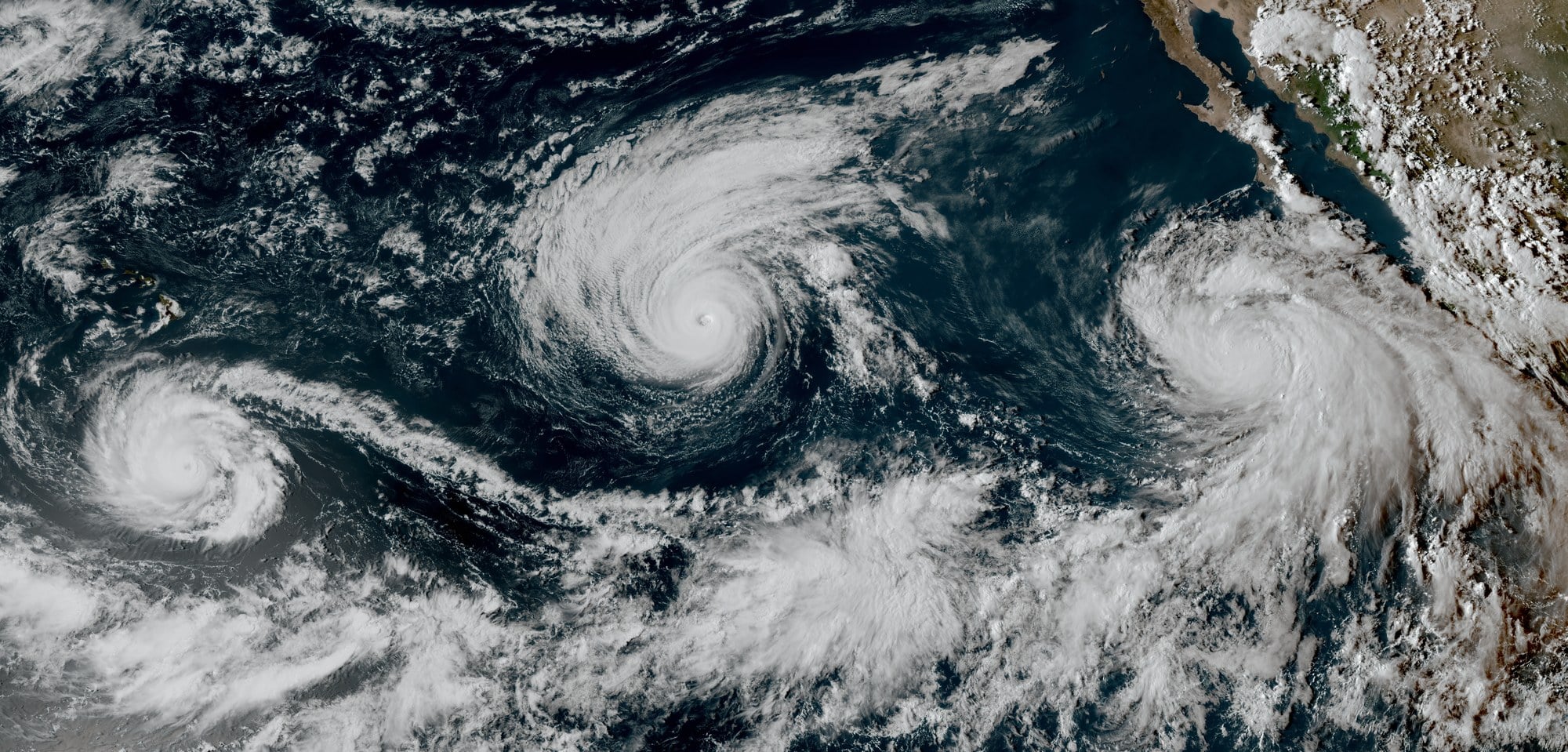
GOES-West view of eastern Pacific tropical cyclones including Marie, 3 September 2026 (NOAA/NESDIS, public domain via Wikimedia Commons).
Hurricane Marie was still well out in the eastern Pacific, hundreds of miles from the California coast and on a track that never brought it ashore, when its energy arrived anyway — as a long south swell breaking on Southern California beaches days before the storm itself was forecast to weaken and unravel. KTLA 5 framed the sequence plainly in its coverage: the surf came first, the storm stayed offshore, and the hazard onshore was water moving in ways swimmers did not expect.
The station’s report tracked the swell as it filled in along south-facing beaches over the Labor Day weekend.
KTLA 5’s coverage of the Labor Day swell is here:
A storm that sends waves without sending itself
Marie reached Category 2 strength with sustained winds near 100 mph, according to Los Angeles Times reporting ahead of the weekend, on a path that kept it north and west of Baja California and well away from any California landfall. Forecasters expected it to weaken toward tropical storm strength and then dissipate, per National Weather Service guidance cited by the Associated Press.
That is the part of the setup that trips people up. A hurricane’s winds churn the ocean surface beneath and around the storm center, and the longest-period waves generated there radiate outward faster than the system itself travels. By the time that energy reaches a coastline hundreds of miles away, it has organized into clean, widely spaced sets that arrive under blue sky. Nothing about the beach looks like a storm. The wave train is the storm’s signature, detached from the storm.
For Southern California, the geometry matters. A south swell slides up from the tropical eastern Pacific and finds the beaches that face it — the south-facing stretches of the Los Angeles and Orange County coasts, the exposed corners of Malibu, the outer islands. Beaches shadowed by points or islands may see little. Two miles down the coast, the same swell can double in size. That variability is why the weather service issues advisories by stretch of coast rather than by a single number, and why wave-height figures in the Marie forecasts were quoted as ranges tied to specific beaches.
The other consequence is the one that fills lifeguard logs. Larger sets push more water up the beach face, and that water has to return offshore, concentrating into rip currents that run seaward through gaps in the sandbars. NWS meteorologist Rose Schoenfeld described the conditions as life-threatening in comments to AP, putting the emphasis on rip currents rather than wave size, and advising beachgoers to swim near lifeguards and stay off rock jetties, where the combination of surge and slick footing is worst.
Advisories on the map, rescues on the sand
The weather service posted coastal flood and high surf advisories covering areas including Malibu and the Los Angeles and Ventura county coasts, along with Santa Catalina and Santa Barbara islands, with the alerts running from the holiday weekend into Tuesday evening, according to the Los Angeles Times. The forecast framing there put the south swell in the 6-to-8-foot range, with Zuma among the spots that could see breaks of 8 to 10 feet. Schoenfeld told AP that south-facing beaches could see surf up to about 10 feet, or roughly three meters. NWS meteorologist Devin Black, quoted by the Times, put the guidance in its simplest form: the best course was to stay out of the water.
The response along the coast was measured in closures and rescue counts. Newport Beach lifeguards made roughly 177 rescues on Saturday, AP reported, citing battalion chief Adam Yacenda — a figure that reflects a single agency on a single day of a multi-day swell, not a regional total. Long Beach issued a health advisory against swimming at its beaches and bays for about three days, tied to runoff rather than wave height. Seal Beach closed two beachfront parking lots through Wednesday morning. The National Hurricane Center warned that dangerous beach conditions would persist for another couple of days.
Rain was the minor note. Light amounts accompanied the system’s moisture, with the Times forecast putting widespread Sunday totals under about a quarter inch, and AP reporting that parts of Los Angeles County had already picked up as much as a quarter inch by Sunday. Enough to wet the pavement and load the storm drains; not enough to be the story.
The lag, the holiday, and the storm that stayed offshore
The timing compounded the risk rather than creating it. Labor Day weekend puts the largest crowds of the late season on the sand, many of them occasional swimmers rather than regular surfers, at exactly the moment a long-period tropical swell was filling in. The days-ahead arrival meant the water was already dangerous while Marie was still a Category 2 system on a satellite loop, before any weather-driven cue — wind, cloud, rain — told beachgoers to reconsider.
Longer term, UC climate scientist Daniel Swain noted to the Times that El Niño conditions typically enhance hurricane activity in the eastern and central Pacific, and that one or two more systems could send conditions toward California later in September or October.
Marie never made landfall in California, and was never forecast to. It tracked north and west of Baja, weakened, and was expected to dissipate offshore. What reached the coast was the wave field it left behind — arriving early, breaking on beaches that faced south, and pulling water back out through rip currents that gave no visual warning at all. The advisories ran through Tuesday evening. The storm that produced them was never coming.
About this column
Deep Field
Deep Field covers astronomy and cosmology. Telescopes and what they find, planets near and far, and the strange physics of the deep universe, traced back to the journal papers and observatory data behind the headlines.