On February 3, 2022, a Falcon 9 lifted 49 Starlink satellites into a deliberately low parking orbit about 210 kilometers above Earth, the standard SpaceX checkout altitude where each spacecraft runs diagnostics before climbing to its operational shell. The next day, a geomagnetic storm so minor that space-weather forecasters expected nothing worse than routine, low-level disturbance puffed up the thermosphere just enough to thicken the air the satellites were skimming through. Within four days, 40 of those 49 satellites had spiraled back into the atmosphere and burned up, a significant single-event loss in the history of the Starlink constellation and, by some accounts, an extremely expensive weather report.
The storm itself was a G1, the lowest category on NOAA’s five-step scale. A G1 is the sort of disturbance that nudges the aurora a little further south and gives power grid operators something to glance at over coffee. It is not the kind of event that anyone, in February 2022, expected to cost a private company tens of millions of dollars in hardware in under a week.
The launch that walked into a wall of air
SpaceX’s deployment strategy for Starlink had always leaned on a low insertion altitude as a safety feature. By dropping the satellites off at roughly 210 kilometers, the company guaranteed that any spacecraft that failed its early health checks would naturally decay within weeks, leaving no long-lived debris. Healthy satellites would fire their krypton ion thrusters and climb to around 550 kilometers. The trade-off was that 210 kilometers sits inside a region of the atmosphere that is unusually sensitive to the Sun.
At that altitude, the air is not quite vacuum. It is a thin soup of atomic oxygen and nitrogen that exerts a small but real drag force on anything moving through it at orbital speed. The density of that soup is not constant. Heat the upper atmosphere by even a few percent and it expands upward, sweeping denser layers into orbital regimes that were previously almost empty. A satellite that was clipping a wisp of gas yesterday can be plowing through measurably thicker air today.
The February 3 storm did exactly that. Charged particles from a coronal mass ejection days earlier deposited energy into the thermosphere, warming it and lifting denser layers into the path of the freshly deployed Starlinks. SpaceX engineers later reported that atmospheric drag during the event was up to 50 percent higher than during previous Starlink launches, enough that the satellites’ attempts to enter a safe edge-on “low-drag” attitude could not save most of them.
A G1 is not supposed to do this
To put the storm in context: NOAA’s scale runs from G1 (minor) through G5 (extreme). The 1989 Quebec blackout was caused by an extreme geomagnetic storm. The Halloween storms of 2003 were similarly severe. The May 2024 storm that pushed aurora as far south as Mexico was a G5. A G1, by contrast, is logged hundreds of times per solar cycle and rarely makes the news. Even the more recent G2 storm that pushed northern lights into New York and Wisconsin in May 2026 was considered a minor-to-moderate event.
The February 2022 event was a reminder that the official geomagnetic categories were designed around ground-based effects, mostly power grid currents and HF radio disruption. They were never calibrated for what a small storm can do to the density of the air at 210 kilometers. A G1 that barely tickles a transformer in Manitoba can still warm the thermosphere enough to delete forty satellites.
That mismatch is now a serious operational problem. Low Earth orbit has gone from a sparsely populated zone to a corridor with thousands of active spacecraft, the majority of them Starlinks. Every one of them is subject to atmospheric drag that varies with solar activity, and the models used to predict that drag were largely built in an era when losing a single satellite to space weather was a research footnote, not a quarterly write-down.
Why the upper atmosphere puffs up
The mechanism is straightforward in outline and miserable in detail. When a coronal mass ejection slams into Earth’s magnetosphere, it dumps energy into the high-latitude ionosphere through resistive heating. Currents driven by the storm flow through the resistive upper atmosphere and warm it, the same way a kettle element warms water. That heat then propagates equatorward and upward over hours, lifting denser air into higher altitudes.
The density at orbital altitudes can increase significantly during a storm. Even during a minor one, increases of 20 to 50 percent are common. For a satellite traveling at roughly 7.8 kilometers per second, a 50 percent increase in air density means a 50 percent increase in drag force, which translates directly into a faster orbital decay. The February 2022 Starlinks were caught at the worst possible moment: low enough that drag mattered, fresh enough that they had not yet climbed to safer altitudes, and oriented for deployment rather than for atmospheric survival.
What SpaceX learned, and what it cost
The 40 satellites that reentered were a small fraction of the constellation but a large fraction of a single launch. SpaceX has adjusted aspects of its deployment profile and procedures for entering low-drag attitude during disturbed conditions. The company has also become one of the most aggressive consumers of space weather forecasts in the commercial sector, a customer base that barely existed a decade ago.
The episode also pushed the broader industry to take space weather risks to satellites more seriously as an underwriting question. Insurance markets for low Earth orbit assets, which had largely ignored solar activity as a covered peril, began revising their assumptions. Operators who had been content with weekly drag updates started asking for hourly ones.
Researchers, meanwhile, treated the loss as a natural experiment. Rocket bodies and old debris in similar orbits have been used as drag probes for decades, and the February 2022 event gave modelers an unusually clean data set: 49 nearly identical objects, deployed at the same time, into the same orbit, with precisely known initial conditions. Their decay rates over the following days became a calibration check for thermospheric density models that had been quietly accumulating errors for years. Work using long-lived rocket debris from the 1960s has helped identify solar activity thresholds past which orbital decay accelerates measurably.
The forecasting gap nobody had budgeted for
The deeper problem the Starlink loss exposed was that the space weather forecasting infrastructure built up over the past forty years was tuned for the wrong customers. It was built for power grid operators, airline polar route planners, and HF radio users. It was not built for an operator with thousands of satellites in a drag-sensitive shell who needs to know, to within a few percent, what the air density at 250 kilometers will be three days from now.
That gap is now driving a wave of work on machine learning approaches to space weather forecasting, including better geomagnetic storm prediction and thermospheric density modeling. The European Space Agency, NOAA, and several university groups have stood up programs specifically aimed at improving short-range density forecasts. New forecasting centers and dedicated space weather instrument suites have been announced on missions that would, a decade ago, have flown without them.
Others are pursuing mitigation rather than prediction. The proposed six-satellite StormWall concept would place spacecraft in geosynchronous orbit and, on command, release clouds of ionized material at the outer edge of Earth’s magnetosphere to reinforce it and blunt an incoming storm’s intensity, by more than 50 percent in early simulations. It is still only a simulation-backed proposal, but it is a measure of how seriously the field now treats a threat that, a decade ago, was largely the concern of grid operators.
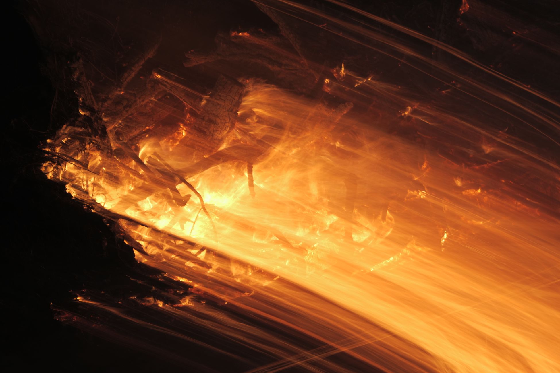
The fiery part
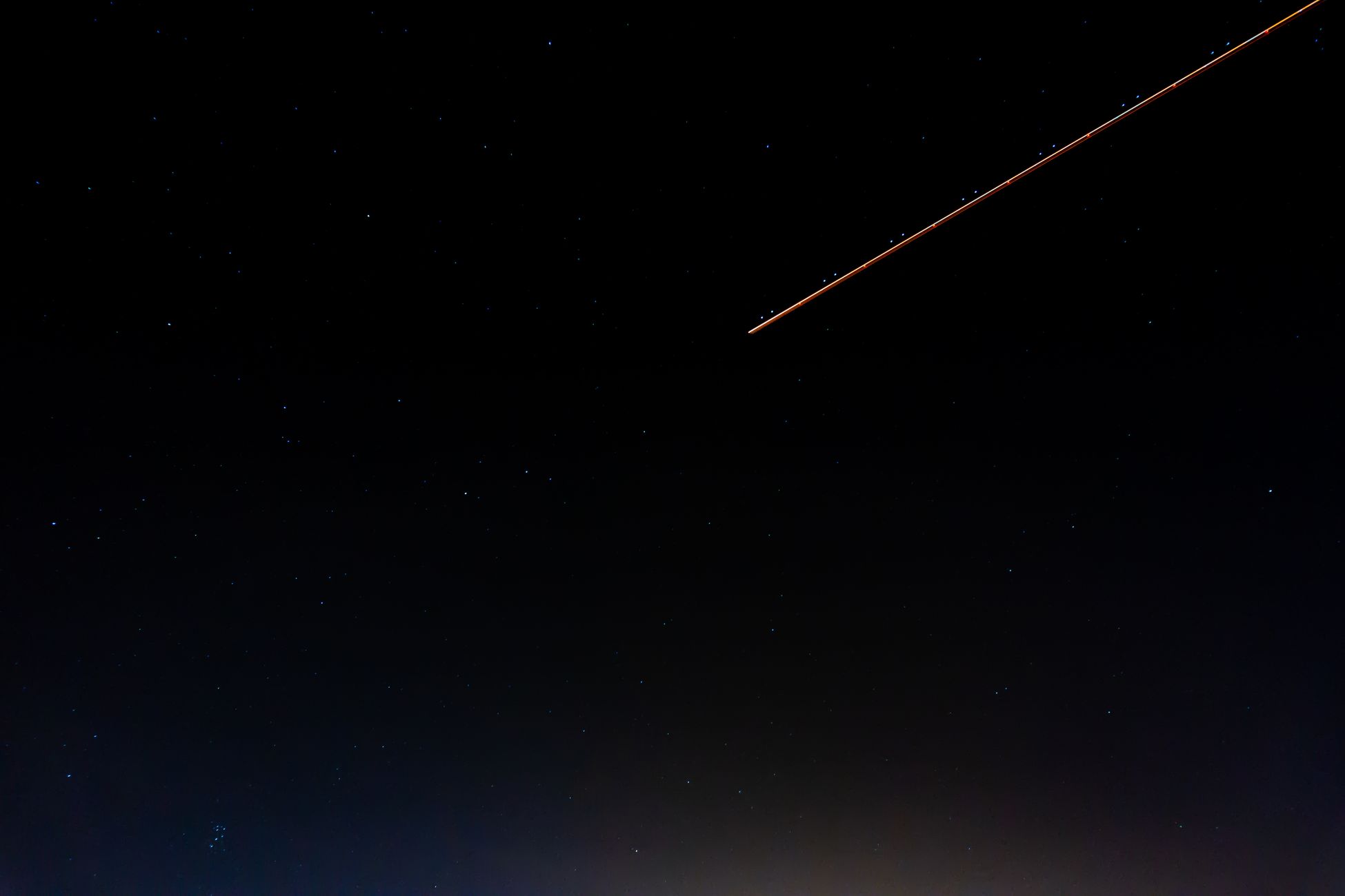
The 40 satellites did not crash. They burned. At 210 kilometers, an aluminum-bodied spacecraft a few meters across reentering at orbital velocity glows white-hot within seconds, sheds panels, and breaks up in the mesosphere. Observers across the Caribbean and Puerto Rico reported streaks of light in the days after February 4 as the satellites came down one by one, each one a brief, bright trail at a few thousand degrees.
The total mass lost was on the order of 11 metric tons of hardware, vaporized into metal oxides that settled into the upper atmosphere over the following weeks. The economic loss was substantial. The scientific value of the data set those satellites generated on the way down has been harder to price, but it has been cited in dozens of papers and continues to shape the way operators think about worst-case solar storm scenarios.
A small storm, a long shadow
Four years on, the February 2022 event is the canonical case study in any briefing on commercial space weather risk. It is the example that gets pulled out when an insurer asks why a G1 should matter, or when a constellation operator wants to argue for a higher initial deployment altitude. It is the moment when the abstract concept that space weather affects satellites acquired a concrete number: forty.
The Sun did not do anything dramatic that week. It produced the kind of mild burp it produces hundreds of times per cycle. The atmosphere did what atmospheres do when you warm them slightly: it got a little taller. And forty satellites, deployed two days earlier into an orbit that had been safe for every previous Starlink mission, fell out of the sky one by one over the Caribbean, each one bright enough to see from a beach.