Most rivers, on any ordinary geographical understanding, end at the ocean. The Amazon reaches the Atlantic. The Nile reaches the Mediterranean. The Mississippi reaches the Gulf of Mexico. The vast majority of freshwater flowing over the surface of the planet at any given moment is on its way, eventually, to the sea. There are exceptions to this pattern, but they are unusual enough that most people, when reading a map, tend to assume that whatever river they are following will eventually connect to something larger, and that whatever they are looking at is part of a system that opens outward toward the world’s oceans.
The Okavango does not. It runs approximately 1,600 kilometres south and east from its source in the highlands of central Angola, cuts across the narrow Caprivi Strip of northern Namibia, enters the north-western corner of Botswana, and then does something that only a small number of rivers on Earth do. It stops. Not at a lake. Not at another river. At sand.
What the delta actually is
According to the World Heritage Datasheet for the Okavango Delta, maintained by the UN Environment Programme’s World Conservation Monitoring Centre and drawn from the site’s UNESCO inscription in June 2014, the delta is what hydrologists call an endorheic system. Endorheic means, in the technical vocabulary, that the water flowing into it has nowhere further to go. There is no outlet. The river arrives, spreads out, and is either absorbed into the ground or lifted back into the atmosphere. UNESCO’s own description of the site places it as one of very few large inland delta systems anywhere on Earth without an outlet to the sea, and as Africa’s largest endorheic delta.
The reason it exists in this specific configuration is geological rather than hydrological. Approximately forty thousand years ago, movements along the southern extension of the African Rift Valley system produced a tectonic trough in what is now north-western Botswana. The Okavango River, which had presumably been flowing further before that, was captured by the trough and forced to spread outward across an ancient alluvial fan rather than continuing on to a downstream outlet. Since that event, the entire flow of the Okavango has ended in the Kalahari.
Related watch – the world’s most untamable river:
The mathematics of what happens next is genuinely arresting. Approximately eleven cubic kilometres of water, meaning eleven billion tonnes, arrive at the delta each year. Approximately ninety-seven per cent of that water, on the hydrological measurements, is subsequently lost to evaporation and transpiration. The remaining fraction either drains into small local pans and lakes at the delta’s edge, most notably Lake Ngami and the Boteti River, or is absorbed into the sand. None of it reaches an ocean. None of it is available for use downstream. Almost all of it is returned to the atmosphere within a matter of weeks after arriving.
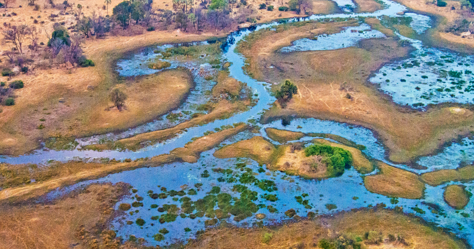
The delta itself, when full, covers between six thousand and fifteen thousand square kilometres of northern Botswana, depending on the season and the volume of water arriving. From the air, it appears as an extraordinary green-and-blue fan spreading southward and eastward from the point at which the Okavango River loses its channelled form, with thousands of interconnected islands, permanent swamps, seasonally flooded grasslands, and slow-moving papyrus-lined channels covering an area roughly the size of Wales.
The paradox of the dry-season flood
The most counter-intuitive feature of the Okavango is when the water arrives. According to an explanatory piece in The Conversation published on the occasion of the delta’s addition as the thousandth site to UNESCO’s World Heritage List in 2014, written by researchers at the University of Bristol and coauthors familiar with the hydrology of the region, rain begins falling in the central highlands of Angola in October. The water then takes roughly four months to travel through the Cubango and Cuito rivers, join to form the Okavango, cross Namibia’s Caprivi Strip, and reach the top of the delta in Botswana. It takes several further weeks to spread through the delta’s system of channels.
Which means that the peak of the flood, in the delta itself, arrives in June, July, and August. Which is, for southern Africa, the middle of the winter dry season. When almost every other water source in the surrounding Kalahari region is at its annual low, the Okavango is at its annual high. Water arrives in the delta at exactly the point in the year when there is no rain falling anywhere nearby, and when the animal populations of northern Botswana are otherwise struggling to find drinking water at all.
The consequence, ecologically, is one of the largest and most reliable wildlife concentrations on the African continent. The delta supports what is currently believed to be the largest continuous elephant population in the world, estimated at approximately one hundred and thirty thousand animals in the surrounding Chobe-Okavango region. It supports significant populations of African lion, spotted hyena, cheetah, leopard, African wild dog, and black rhinoceros. It supports the world’s densest concentration of African fish eagle. It supports several hundred bird species. And it does all of this in the middle of one of the driest and hottest landscapes on the continent, because the water arrives at exactly the right time of year to sustain the whole system through the season when nothing else can.
What the whole system points at
The Okavango Delta is one of the more genuinely improbable pieces of geography anywhere on Earth. A river as long as the distance from London to Rome runs from a tropical highland into a desert, ends in the sand, is entirely evaporated, and in doing so sustains a wildlife population that would otherwise be impossible in the surrounding landscape. Its water never reaches the sea. Its rain, once it has fallen on Angola, will spend a few months in the ground and the atmosphere over Botswana, and then be returned to the sky, and drift somewhere else, and eventually fall again as different rain, on a different landscape, with no continuous downstream story linking one end of the process to the other.
The main current threat to the whole system, according to UNESCO and the three governments involved in its management through the joint Okavango River Basin Commission, is the possibility of large-scale water abstraction upstream. Angola, which has been rebuilding after a long civil war that ended in 2002, has proposed irrigation schemes and hydroelectric dams on the Cubango and Cuito rivers. Namibia has periodically proposed extracting water from the Okavango for agricultural and municipal use in its own dry interior. Any significant reduction in the volume of water reaching Botswana would reshape the delta within a few decades, and would reshape the ecosystem it supports within a shorter period than that.
None of the water that reaches the delta today has ever done so on the assumption that it would. It is the result of a specific accident of tectonic geology forty thousand years old, sustained by a specific pattern of continental rainfall that could shift in either direction under a warming climate, and channelled through a river system whose upstream states have historically not developed the capacity to withdraw water from it at scale. What that leaves, at the level of the map, is one of the strangest features on the surface of the planet. A great river that goes nowhere. And a wildlife system that depends, entirely, on the fact that it does.
Kiran Athar is a writer, not a hydrologist or a wildlife biologist. This piece draws on the UNESCO World Heritage documentation for the Okavango Delta and academic coverage of the site’s ecology and hydrology.