| . |  |
. |
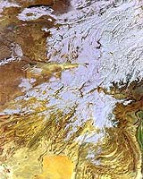
Paris, France (ESA) Jan 23, 2006 Winter snow blankets the heights of the Pamir Mountains and the Hindu Kush in this Envisat image acquired over Central Asia, the snow cover extending to surrounding desert lowlands. The image covers a jigsaw of national territories including western Pakistan, Afghanistan, eastern Iran, Turkmenistan, Uzbekistan and Tajikistan. This region is well known for harsh winters. The snow-covered Hindu Kush covers much of the image, the western section of an extended mountain range system that encompasses the Pamir and Karakorum Mountains and the Himalayas. The average altitude of the Hindu Kush is 4500 metres. The overall Hindu Kush-Himalaya system includes the highest elevations on Earth and makes up the greatest concentration of ice and snow outside the Polar Regions. Many major rivers flow from it, with the system estimated to supply water for 500 million people across the region. Prominent to the south is the yellow expanse of Afghanistan's Rigestan desert plateau, with rippled sand dunes visible on its eastern side. On the western side can be seen the Helmand River as it flows south from the Hindu Kush. The Helmand intermittently flows into marshland connected to the greenish lakes seen on the western edge of the image, near the city of Zabol just over the border with Iran. The Afghan city of Kandahar is located on the northern extremity of Rigestan. Further north can be seen a longer water course running down from the Hindu Kush: known to the ancient Greeks as the Oxus River, this river flows for 2400 km across the arid region. Its course can be seen about two thirds of the way up the image, initially running west where it demarcates the border between Afghanistan and Tajikistan � today known as the Panj � before turning to the northwest to trace the border between Turkmenistan and Uzbekistan � where its title changes to the Amu Darya. The Amu Darya once ran all the way west into a delta connected to the Aral Sea, but today extensive diversion of its waters for irrigation means that it runs dry in the intervening desert. Further north can be seen a dark, elongated water body, its southern side dusted with snow. This is the human-made Lake Aydarkul in southeast Uzbekistan. It has a length of 140 km. Lake Aydarkul was formed during Soviet times by water from Kazahstan's Chardara dam across the Syr Darya River being diverted into a natural feature called the Arnassay Depression. The Syr Darya River flows northwest towards the Aral Sea (part of its course through snow-dusted plains can be seen by clicking to see the full, high-resolution image) although like the Amu Darya River further south it nowadays dries up long before reaching it. This is part of an image acquired on 5 January 2006 by Envisat's Medium Resolution Imaging Spectrometer (MERIS) working in Reduced Resolution mode. It has a spatial resolution of 1200 m and a width of 1345 km. Related Links
 Vandenburg AFB CA (SPX) Jan 23, 2006
NASA's Imager for Magnetopause-to-Aurora Global Exploration (IMAGE) satellite recently ceased operations, bringing to a close a successful six-year mission. IMAGE was the premier producer of new discoveries on the structure and dynamics of the Earth's external magnetic field (magnetosphere) and its contents. |
|
| The content herein, unless otherwise known to be public domain, are Copyright 1995-2006 - SpaceDaily.AFP and UPI Wire Stories are copyright Agence France-Presse and United Press International. ESA PortalReports are copyright European Space Agency. All NASA sourced material is public domain. Additionalcopyrights may apply in whole or part to other bona fide parties. Advertising does not imply endorsement,agreement or approval of any opinions, statements or information provided by SpaceDaily on any Web page published or hosted by SpaceDaily. Privacy Statement |

