| . |  |
. |
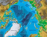
Durham NH (SPX) Feb 12, 2008 New Arctic sea floor data released today by the University of New Hampshire and the National Oceanic and Atmospheric Administration suggests that the foot of the continental slope off Alaska is more than 100 nautical miles farther from the U.S. coast than previously assumed. The data, gathered during a recent mapping expedition to the Chukchi Cap some 600 nautical miles north of Alaska, could support U.S. rights to natural resources of the sea floor beyond 200 nautical miles from the coast. "We found evidence that the foot of the slope was much farther out than we thought," said Larry Mayer, expedition chief scientist and co-director of the Joint Hydrographic Center at UNH. "That was the big discovery." Coastal nations have sovereign rights over the natural resources of their continental shelf, generally recognized to extend 200 nautical miles out from the coast. The Law of the Sea Convention, now under consideration in the U.S. Senate, provides nations an internationally recognized basis to extend their sea floor resource rights beyond the foot of the continental slope if they meet certain geological criteria backed up by scientific data. The Bush administration supports approval of the convention. The Arctic mapping expedition, conducted between Aug. 17 and Sept. 15, 2007 aboard the U.S. Coast Guard Cutter Healy, employed sophisticated echo sounders to survey this relatively unexplored region, providing much finer-grained data and images than existed previously. The data is available. "We now have a better geologic picture of what's happening in that area of the Arctic," said NOAA Office of Coast Survey researcher Andy Armstrong, co-chief scientist on the expedition and NOAA co-director of the Joint Hydrographic Center. "These are valuable data for NOAA and the United States, and I'm pleased that we're making them available for anyone to use." Mapping more than 5,400 linear nautical miles, the research team also found scours on the Chukchi Cap some 1,300 feet below the surface, likely caused by the scraping of an ice sheet on the sea floor, and deep pockmarks of unknown origin at a depth of 1,600 feet. "The sea floor is full of mysteries, and beneath the Arctic ice cap those mysteries are even harder to reveal," said Mayer. "The kind of full-coverage, high-resolution mapping we do provides critical insight for meeting the criteria of the Law of the Sea Convention as well as the geologic history of the region." Prior to this work, the only seafloor mapping data available in the ice-covered Arctic came mostly from ice islands and helicopters. These sparse individual measurements produced low-resolution maps compared to the Joint Hydrographic Center's mapping. Other mapping expeditions led by the Joint Hydrographic Center, a NOAA-UNH partnership, have explored the Bering Sea (2003), the Atlantic coast of the U.S. (2004 and 2005), the Gulf of Alaska (2005), Mariana Islands (2006 and 2007), and the Gulf of Mexico (2007). "Understanding the bathymetry and geological history of the Arctic is an important part of understanding global climate change," said Mayer. "The Arctic acts as a global spigot in controlling the flow of deep ocean currents that distribute the Earth's heat and control climate. The Arctic is the canary in the coal mine."
Community
 Boulder CO (SPX) Jan 29, 2008
A new University of Colorado at Boulder study has shown that ice caps on the northern plateau of Baffin Island in the Canadian Arctic have shrunk by more than 50 percent in the last half century as a result of warming, and are expected to disappear by the middle of the century. |
|
| The content herein, unless otherwise known to be public domain, are Copyright 1995-2007 - SpaceDaily.AFP and UPI Wire Stories are copyright Agence France-Presse and United Press International. ESA Portal Reports are copyright European Space Agency. All NASA sourced material is public domain. Additional copyrights may apply in whole or part to other bona fide parties. Advertising does not imply endorsement,agreement or approval of any opinions, statements or information provided by SpaceDaily on any Web page published or hosted by SpaceDaily. Privacy Statement |