| . |  |
. |
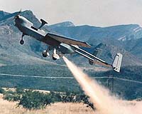
San Diego CA (SPX) Apr 12, 2005 Northrop Grumman has conducted the first flight of a new configuration of the U.S. Army's RQ-5A unmanned aerial vehicle system called the Endurance Hunter (E-Hunter). Conducted March 17 at a company flight test facility near Douglas, Ariz., the flight is part of an on-going cooperative effort between Northrop Grumman and the U.S. Army to extend the range, endurance and payload capacity of the Hunter system. Northrop Grumman operated the new UAV under the control of a prototype "One System" ground control station. The E-Hunter combines the fuselage of the battle-proven Hunter UAV with a new tail assembly and a longer center wing to create a UAV that can fly missions up to 30 hours in length, at altitudes in excess of 20,000 feet. "We developed E-Hunter and its ground control station as part of a cooperative agreement between Northrop Grumman and the Army," explained Doug Valenzuela, Northrop Grumman's E-Hunter program manager. "E-Hunter combines the internal payload carrying capability of the RQ-5A Hunter with a longer wing and tail booms that can carry a variety of external sensors, communications and weapons payloads. "It's also a cost-effective way for the Army to ramp up its UAV capabilities. Using only a field-installable kit, we can convert any of the service's current Hunter UAVs into a higher- performance, longer-endurance UAV." "The wing and tail assembly used on E-Hunter are identical to those used on Hunter II, Northrop Grumman's offering for the Army's next generation Extended Range/Multi-Purpose UAV program," added Valenzuela. The goal of the initial flight was to evaluate E-Hunter's controllability and handling characteristics. After several high-speed taxi runs, the air vehicle lifted off at a speed of 47 knots. At an altitude of 2,000 feet, the company's flight operations team conducted a series of controllability tests at 60 knots and 80 knots. After a series of low-approach passes to validate low-speed handling and to visually verify landing gear and arresting hook extension, the air vehicle landed at a speed of approximately 48 knots. The prototype Army One System ground control station used for the E-Hunter flight was produced by Northrop Grumman with its own funding. The One System approach allows the Army to use the same ground control station to operate and control several types of tactical UAVs. "With this test flight, we've now demonstrated that we can use One System-like ground control stations to operate Hunter, Hunter II and E-Hunter UAVs," said Valenzuela. "The company plans to conduct additional E-Hunter 'envelope expansion' flights in the near future to demonstrate the UAV's ability to fly at higher altitudes for longer periods of time," he added. Related Links Northrop Grumman SpaceDaily Search SpaceDaily Subscribe To SpaceDaily Express
 Manassas VA (SPX) Apr 11, 2005
Aurora Flight Sciences announced last Thursday that it delivered the first aft fuselage for the new RQ-4B model of the Global Hawk unmanned aerial vehicle to prime contractor Northrop Grumman. |
|
| The content herein, unless otherwise known to be public domain, are Copyright 1995-2006 - SpaceDaily.AFP and UPI Wire Stories are copyright Agence France-Presse and United Press International. ESA PortalReports are copyright European Space Agency. All NASA sourced material is public domain. Additionalcopyrights may apply in whole or part to other bona fide parties. Advertising does not imply endorsement,agreement or approval of any opinions, statements or information provided by SpaceDaily on any Web page published or hosted by SpaceDaily. Privacy Statement |