| . |  |
. |
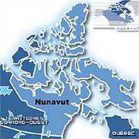
Ottawa, Canada (SPX) Aug 26, 2005 The Honourable R. John Efford, Minister of Natural Resources Canada (NRCan), and Nancy Karetak-Lindell, Member of Parliament for Nunavut, on behalf of the Honourable Andy Scott, Minister of Indian Affairs and Northern Development, has announced the start of the Qikiqtani Inuit Association's aeromagnetic survey of Nunavut's South Baffin region. The Government of Canada, through Indian and Northern Affairs Canada (INAC), is investing $1 million to support the aeromagnetic survey, which builds upon a previous $1.02 million invested to support NRCan's predictive mapping project. "Canada's North is a vast area of unique cultural and ecological significance that also holds great economic potential," said Minister Efford. "Coupling NRCan's predictive mapping project with this aeromagnetic survey will stimulate research and exploration in new areas of the region and benefit communities throughout Nunavut." "Aeromagnetic mapping is a necessary part of the basic geoscientific infrastructure required by industry, academia, governments and the public. By supporting this, INAC and NRCan are demonstrating the Government of Canada's commitment to furthering geoscience infrastructure in Nunavut," said Ms. Karetak-Lindell. "Partnerships between federal departments and regional Inuit associations will continue to support this infrastructure and attract much-needed investment in the territory." Thomasie Alikatuktuk, President of the Qikiqtani Inuit Association, said he is pleased to see support for this initiative. "This is an excellent example of the Government of Canada and Inuit working together," he said. "It is encouraging to know that the results of this survey will attract private-sector interest to the South Baffin region to the benefit of both Inuit and the Crown. The commitment made by Minister Scott and Minister Efford is an investment in Nunavut's future." NRCan will combine the aeromagnetic data of Nunavut's South Baffin region with other available geoscience data, including satellite imagery, to create a predictive map that will be used to guide ground-based bedrock mapping. The initiative will assist Inuit in identifying carving- stone resources, aid exploration companies in their search for minerals, reduce field and mapping costs, allow public access to mapping and geological information, and increase industry investment in Nunavut on both Crown and Inuit-owned land. The funding for the survey is part of the $90 million for Northern Economic Development that was announced in Budget 2004. The survey will help advance the Government of Canada's commitment to the sustainable development of our natural resources. The Government is committed to building on the strength of our country and our people, with all their diversity, knowledge and determination. The natural resources sectors and allied industries are a vital part of Canada's economy and society. This initiative is consistent with the goal of establishing strong foundations for sustainable economic development, one of the seven key goals of the proposed Northern Strategy Framework released by the Prime Minister and Territorial First Ministers on December 14, 2004. Related Links Northern Strategy SpaceDaily Search SpaceDaily Subscribe To SpaceDaily Express
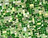 Greenbelt MD (SPX) Aug 26, 2005
Resembling a work of modern art, variegated green crop circles cover what was once shortgrass prairie in southwestern Kansas. The most common crops in this region�Finney County�are corn, wheat, and sorghum. |
|
| The content herein, unless otherwise known to be public domain, are Copyright 1995-2006 - SpaceDaily.AFP and UPI Wire Stories are copyright Agence France-Presse and United Press International. ESA PortalReports are copyright European Space Agency. All NASA sourced material is public domain. Additionalcopyrights may apply in whole or part to other bona fide parties. Advertising does not imply endorsement,agreement or approval of any opinions, statements or information provided by SpaceDaily on any Web page published or hosted by SpaceDaily. Privacy Statement |