| . |  |
. |
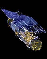
Dulles VA (SPX) Apr 20, 2006 GeoEye, the world's largest satellite remote-sensing imaging company through its partner European Space Imaging (EUSI) has received an additional contract from the European Commission to supply OrbView-3 high-resolution map-accurate imagery. The contract was awarded on April 5, 2006 and is valued at $2.15 million (EUR 1.8 million) over the next four years. The imagery will be collected by the company's OrbView-3 high-resolution earth-imaging satellite. Together with its recently renewed three-year contract to supply imagery from GeoEye's IKONOS high-resolution satellite, EUSI continues to be one of the largest suppliers of commercial satellite imagery to the European Commission. The imagery will be processed and delivered to the European Commission by EUSI located in Munich, Germany. The contract requires GeoEye to begin imagery collections over 24 specific European sites to support the European Commission's agricultural subsidy controls. The European Union is using satellite imagery as a tool to verify farmer's declarations and claims for subsidies. In addition, the European Commission will use OrbView-3 imagery in support of national security related projects. "The European Commission has been an excellent customer, and we are committed to continuing to meet all of their expectations," said Adrian Zevenbergen, general manager for European Space Imaging. "For the past three years the European Commission has ranked GeoEye's IKONOS satellite with a 98-100% performance success rate, so we are confident the OrbView-3 satellite will maintain this contract's same demanding schedule and performance requirements." "We are delighted that the European Commission has chosen to use imagery from the OrbView-3 satellite in support of agricultural subsidy controls as well as for security related projects. OrbView-3 has been used by several Asian countries as well as by the US Government's National Geospatial-Intelligence Agency for similar purposes. "This contract will now give us an opportunity to demonstrate this satellite's capability and value to the European community," said Timothy J. Puckorius, GeoEye's senior vice president of International Sales. GeoEye is currently building its next-generation commercial satellite imaging system, GeoEye-1, which will have a ground resolution of .41-meter panchromatic and 1.65-meter multispectral. When launched in early 2007, this satellite will greatly increase our capacity to collect a large amount of data within a short timeframe, which is ideal for monitoring crop subsidy programs. Related Links GeoEye
 Washington DC (SPX) Feb 06, 2006
San Diego VA (SPX) Apr 20, 2006 Science Applications International Corporation (SAIC) has completed the acquisition of Geo-Spatial Technologies, Inc. (GSTI), a Springfield, Va., and Seattle, Wa., firm that is a leader in the research, development, and application of novel geospatial technology for advanced 3-D imaging, reconnaissance, remote sensing and mapping systems. |
|
| The content herein, unless otherwise known to be public domain, are Copyright 1995-2006 - SpaceDaily.AFP and UPI Wire Stories are copyright Agence France-Presse and United Press International. ESA PortalReports are copyright European Space Agency. All NASA sourced material is public domain. Additionalcopyrights may apply in whole or part to other bona fide parties. Advertising does not imply endorsement,agreement or approval of any opinions, statements or information provided by SpaceDaily on any Web page published or hosted by SpaceDaily. Privacy Statement |