| . |  |
. |
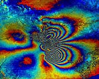
Paris, France (ESA) Nov 13, 2007 Every year geohazards - such as volcanoes, earthquakes, landslides and tsunamis - claim thousands of lives, devastate homes and destroy livelihoods. In an effort to reduce their impact, more than 250 scientists from around the world gathered for a five-day workshop at ESA's Earth Observation Centre in Frascati, Italy, to adopt a declaration for an internationally coordinated programme to help save lives and reduce human suffering worldwide. Because of their unique, panoramic view from space, Earth Observation (EO) satellites can regularly monitor high-risk regions - namely over volcanoes, major landslides and seismic faults. Satellite imagery combined with in-situ measurements make it possible to produce hazard maps, disaster scenarios, forecasts and post-event assessments maps. "This workshop is very beneficial because it attracts experts from approximately 40 countries in the field of geohazards and allows us to present results of EO applications from our respective countries," Dr Vernon H. Singhroy, Senior Research Scientist at the Canada Centre for Remote Sensing, said. "ESA is leading the way in satellite observations and applications for geohazards," Singhroy continued. "As a community, we learn from the extensive applications of geohazard processes, such as InSAR monitoring, across Europe conducted through ESA programmes. Data from Synthetic Aperture Radar (SAR) instruments like those flown aboard ESA's Envisat and ERS-2 satellites are the basis for a technique called SAR interferometry, or InSAR for short. InSAR involves combining two or more radar images of the same ground location in such a way that very precise measurements - down to a scale of a few millimetres - can be made of any ground motion taking place between image acquisitions. Because very small movements can potentially be detected across tectonic plates grinding past one another or the slow 'breathing' of active volcanoes, for example, InSAR has achieved spectacular results in various fields such as the monitoring of volcanoes, earthquakes, landslides and land subsidence. "The integration of in-situ observations with satellite observations helps us to better understand and forecast specific geological phenomena like volcanoes and seismic sites," said Jacques Varet, Director of Strategic Planning for Geoscience for a sustainable Earth (BRGM) and Vice President of EuroGeoSurveys. "In-situ observations have a local approach while space-based observations have a global approach. With these communities working together, we integrate our approach and enlarge our horizon."
Volcanoes To boost the use of EO data at volcanic observatories, ESA has started to monitor volcanoes worldwide within the framework of the Agency's Data User Element programme. The Globvolcano project, started in early 2007, will define, implement and validate information services to support volcanological observatories in their daily work by integration of EO data, with emphasis on observation and early warning.
Earthquakes Interferometry provided a unique insight into the cause of the earthquake in Bam, Iran, in December 2003, which resulted in the deaths of 26 000 people. Studying radar images of the ground around Bam before and after the quake allowed scientists to construct an interferogram and tell geologists in Iran that the fault was actually in a different place than previously thought.
Landslides This technique was the basis of another ESA Data User Element project called Service for Landslide Monitoring (SLAM), which enabled landslide susceptibility mapping across parts of Italy and Switzerland, two of the European countries most under threat. In compliance with GEO (Group on Earth Observations) data policy, scientists have adopted a declaration that, among other requests, calls upon space and in-situ monitoring agencies to release data available over a limited number of high-risk areas. This will allow a better understanding of hazards and allow informed decision making to reduce geological risks. Community Email This Article Comment On This Article Related Links Earth Observation News - Suppiliers, Technology and Application
 Milpitas CA (SPX) Nov 08, 2007
SPOT announced that SPOT, the world's first satellite messenger, is available for purchase and activation. SPOT is now offering the messenger and service online. In addition, major outdoor, online, wireless and electronics retailers will carry limited stock of SPOT later in November, in time for the holiday gift-giving season. |
|
| The content herein, unless otherwise known to be public domain, are Copyright 1995-2007 - SpaceDaily.AFP and UPI Wire Stories are copyright Agence France-Presse and United Press International. ESA Portal Reports are copyright European Space Agency. All NASA sourced material is public domain. Additional copyrights may apply in whole or part to other bona fide parties. Advertising does not imply endorsement,agreement or approval of any opinions, statements or information provided by SpaceDaily on any Web page published or hosted by SpaceDaily. Privacy Statement |