| . |  |
. |
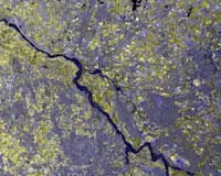
Paris, France (SPX) Apr 17, 2006 ESA's ERS-2 satellite has been helping German authorities monitor and attempt to mitigate the effects of torrential rains and melting snow, which caused the Elbe River to rise to a record high level in northern parts of the country last weekend, flooding cities and damaging historic town centers. The medieval city of Hitzacker, located in Lower Saxony about 100 kilometers (62 miles) from the Baltic Sea, was one of the hardest-hit areas. There, the Elbe rose 7.63 meters (about 25 feet) above its normal level on Sunday, threatening severe damage to historic houses, some of which are over 400 years old. In October 2000, ESA and other national space agencies established the International Charter on Space and Major Disasters to provide resources to rescue authorities responding to major natural or human-caused disasters. When the Elbe floods began, the German Joint Information and Situation Centre requested maps of the flooded region. In response, the Charter members recruited the German Aerospace Center to produce the maps using satellite images provided by the space agencies. The DLR used ERS-2 Synthetic Aperture Radar images to delineate the flooded areas. Flood-protection and water-management agencies in the German states of Saxony, Saxony-Anhalt, Brandenburg and Lower Saxony, along with the city of Dresden's Department for Environment, used the ERS-2 maps. The police department of Potsdam also used the information to coordinate their forces. By Tuesday, the severe flooding in Germany had abated, but saturated dykes in some areas remain under strain. Authorities have deployed about 3,000 rescue workers to the affected areas in recent days to reinforce dykes and distribute sandbags along the Elbe. Hitzacker officials said the Elbe's water level reached 13 centimeters (about six inches) higher than it did in the devastating floods in the summer of 2002, which saw water levels reach 150-year highs across parts of Central and Eastern Europe. The DLR performed the service under the scope of the Risk-EOS service network � an initiative of ESA offering EO-based operational services for flood risk management, including rapid mapping of major disasters. Risk-EOS is part of ESA's initial Services Element of Global Monitoring for Environment and Security, a joint initiative between ESA and the European Commission to develop a global monitoring capability for Europe harnessing all available ground- and space-based data sources. Floods constitute the world's most costly natural disasters. With inundated areas typically visible from orbit, governments are increasingly employed Earth-observing satellites to help guide flood response and mitigation. Related Links ERS-2 RISK-EOS GMES
 Taipei, (AFP) Apr 16, 2006
A rocket carrying six Taiwanese weather satellites has been successfully launched from California's Vandenberg Air Force Base, officials said Sunday. |
|
| The content herein, unless otherwise known to be public domain, are Copyright 1995-2006 - SpaceDaily.AFP and UPI Wire Stories are copyright Agence France-Presse and United Press International. ESA PortalReports are copyright European Space Agency. All NASA sourced material is public domain. Additionalcopyrights may apply in whole or part to other bona fide parties. Advertising does not imply endorsement,agreement or approval of any opinions, statements or information provided by SpaceDaily on any Web page published or hosted by SpaceDaily. Privacy Statement |