| . |  |
. |
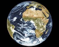
Paris France (SPX) Mar 19, 2006 ESA will unveil a frieze depicting the entire planet Earth, made up of one-millionth-scale satellite images, around UNESCO's headquarters building on March 29. The "Belle Ile en Ciel," or "Beautiful Island in the Sky," exhibition, organized by UNESCO as part of its 60th birthday observation, will open in the presence of UNESCO Director General Ko�chiro Matsuura, ESA Director General Jean-Jacques Dordain and Parc Europeen du Volcanisme 'Vulcania' President Jean Mallot. The exhibit, supported by ESA, the Parc europeen Vulcania, PlanetObserver, Spot Image, RATP and L'Express, will give visitors a view of the Earth compiled from the PlanetObserver database, will feature some 60 charts graphically illustrating the main environmental challenges facing humanity at large, including managing the water cycle, biodiversity, pollution, deforestation, global warming, managing natural disasters, plus education, communication, dialogue among civilizations and the preservation of specific cultures. The exhibit will run through Nov. 4.
Related Links
 Paris France (SPX) Mar 17, 2006
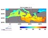
ESA scientists have switched their satellite surveys to nighttime to obtain better data on the temperature of the Mediterranean Sea and elsewhere in the waters surrounding Europe. The space agency's Earth scientists consider sea-surface temperature an important index for weather and ocean forecasting, and a key indicator of climate change. |
|
| The content herein, unless otherwise known to be public domain, are Copyright 1995-2006 - SpaceDaily.AFP and UPI Wire Stories are copyright Agence France-Presse and United Press International. ESA PortalReports are copyright European Space Agency. All NASA sourced material is public domain. Additionalcopyrights may apply in whole or part to other bona fide parties. Advertising does not imply endorsement,agreement or approval of any opinions, statements or information provided by SpaceDaily on any Web page published or hosted by SpaceDaily. Privacy Statement |