| . |  |
. |
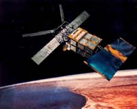
London, England (SPX) Apr 20, 2006 British scientists said Thursday they have discovered rivers the size of the Thames in London flowing hundreds of miles under the eastern Antarctica ice shelf. The team studied small changes in elevation, as observed by ESA's ERS-2 satellite, in the surface of the oldest, thickest ice in the region, to detect the rivers. The finding challenges the widely held assumption that sub-glacial lakes evolved in isolated conditions for several million years, and it raises the possibility that water from deep within the ice's interior may have generated huge floods that reached the ocean in the past - and may do so again. "Previously, it was thought that water moves underneath the ice by very slow seepage," said team leader Duncan Wingham, of the University College London. "But this new data shows that, every so often, the lakes beneath the ice pop off like champagne corks, releasing floods that travel very long distances." The researchers found anomalies in the ice sheet's surface elevations using ultra-precise measurements from ERS-2's radar altimetry and radar interferometry. Close inspection of one anomaly revealed an abrupt fall in ice-surface elevation with a corresponding abrupt rise some 290 kilometers (180 miles) away. The only possible explanation for these changes is a large flow of water was transferred beneath the ice from one sub-glacial lake into several others, the researchers said. Radar altimeters - originally designed to measure sea-surface height by beaming down 1,800 radar pulses per second, then recording how long their echoes take to bounce back - have been highly successful in measuring large-scale ice surface changes over time. Radar interferometry, known as InSAR, is used to measure the spatial pattern of the changes precisely. Together, they form a powerful instrument to investigate the physical causes of changes in the ice surface. Wingham, who is director of the university's Center for Polar Observation and Modeling, said the sensors proved essential for the study. "With radar altimetry we can tell how much the lake levels fell and rose, and that it occurred between late 1996 and early 1998, but we cannot determine the area, which is vital for investigating the physics of the flood because we need to know the volume of water involved," he said. For that reason, he added, " we turned to ERS-2 InSAR interferometry, which has excellent spatial resolution. With it, we were able to image the area of at least part of one lake, which was enough to give us an idea of the volume, and with this we could get at the rate of the flow." Sub-glacial lakes in Antarctica first were identified in the 1960s. Since then, more than 150 have been discovered, but thousands more may exist, because much of the bed of Antarctica remains unexamined. The team focused its study on the Dome Concordia region in eastern part of the continent, which features more than 40 known lakes. Several groups, under the umbrella of the Scientific Committee on Antarctic Research, currently are investigating the prospect of drilling down to sub-glacial Antarctic lakes where ancient life is thought to exist. Because of this discovery, however, scientists might have to review their plans. "A major concern has been that by drilling down to the lakes new microbes would be introduced," Wingham said. "Our data show that any contamination will not be limited to one lake, but will over time extend down the length of the network of rivers. We had thought of these lakes as isolated biological laboratories. Now we are going to have to think again." Related Links ERS-2 ESA
 Gainesville FL (SPX) Apr 21, 2006
Ancient fish teeth are yielding clues about when Antarctica became the icy continent it is today, highlighting how ocean currents affect climate change. University of Florida geologists have used a rare element found in tiny fish teeth gathered from miles below the ocean surface to date the opening of a passage at the bottom of the globe between the Atlantic and Pacific. |
|
| The content herein, unless otherwise known to be public domain, are Copyright 1995-2006 - SpaceDaily.AFP and UPI Wire Stories are copyright Agence France-Presse and United Press International. ESA PortalReports are copyright European Space Agency. All NASA sourced material is public domain. Additionalcopyrights may apply in whole or part to other bona fide parties. Advertising does not imply endorsement,agreement or approval of any opinions, statements or information provided by SpaceDaily on any Web page published or hosted by SpaceDaily. Privacy Statement |