| . |  |
. |
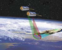
Berlin, Germany (SPX) May 18, 2006 The German Space Agency DLR and EADS Astrium announced Wednesday at the ILA-Airshow their intention to build a new radar satellite called TanDEM-X. TanDEM-X, scheduled for launch in 2009, along with the almost identical radar satellite TerraSAR-X, to be launched in autumn this year, will form a high-precision interferometer. Like TerraSAR-X, TanDEM-X will be constructed by the public-private partnership between EADS Astrium and DLR. The space agency's institute for microwaves and radar will manage the project in cooperation with Infoterra, an EADS subsidiary. The spacecraft will cost approximately 85 million Euros ($110 million), of which DLR will finance 56 million Euros. EADS Astrium will contribute 26 Million Euros, and the remainder will be raised by selling opportunities for further payloads. TerraSAR-X and TanDEM-X, operating in tandem, will make it possible to measure Earth's entire land surface � about 150 million square kilometers (60 million square miles) - within a period of only 2.5 years. Within a grid 12 meters (40 feet) square, height information could be determined within 2 meters (6.5 feet). The mission's goal is the generation of a worldwide, consistent and homogeneous terrain model with no discontinuity at regional or national borders and no inconsistencies resulting from different measurement protocols or measurement efforts staggered in time. Radar measurement offers the advantage of being able to operate independent of weather and light conditions. The United States is the leader in this observation method. �TanDEM-X is a key project for demonstrating, safeguarding and extending the German competence and competitiveness in the field of satellite-based radar technology,� DLR and EADS said in a joint statement. The agency said it plans to use the global digital terrain model in initiatives and programs such as ZKI, Germany's center for satellite-based crisis information; Global Monitoring for Environment and Security, and Global Earth Observation System of Systems, as well as in cooperative security agreements.
Related Links
 Paris, France (SPX) May 18, 2006
ESA has for the first time acquired and processed images sent by ALOS � Japan's four-ton satellite dedicated to land-based Earth observation � including views of Italy, the Netherlands and Norway. ESA is utilizing its facilities and expertise to acquire, process and distribute data from the satellite. |
|
| The content herein, unless otherwise known to be public domain, are Copyright 1995-2006 - SpaceDaily.AFP and UPI Wire Stories are copyright Agence France-Presse and United Press International. ESA PortalReports are copyright European Space Agency. All NASA sourced material is public domain. Additionalcopyrights may apply in whole or part to other bona fide parties. Advertising does not imply endorsement,agreement or approval of any opinions, statements or information provided by SpaceDaily on any Web page published or hosted by SpaceDaily. Privacy Statement |