| . |  |
. |
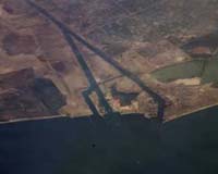
Houston TX (SPX) Aug 30, 2006 If you viewed one a day, it would take more than 500 years to see them all. If you printed and stacked them on top of each other, they'd reach taller than a six-story building. And if you leafed through them at a leisurely pace, they'd show you the amazing wonder of Earth, as seen from the International Space Station. A space station crew member recently took the 200,000th photograph acquired from on board the orbiting laboratory. The subject? A northbound column of cargo ships entering the Mediterranean Sea on June 30 from the Suez Canal in Egypt. Since that time, additional imagery taken by Expedition 13 crew members Jeffrey Williams, Pavel Vinogradov and Thomas Reiter has brought the total number of images of Earth taken from station beyond 248,000. The Suez Canal connects Port Said on the Mediterranean Sea with the port of Suez on the Red Sea. The human-engineered waterway provides an essentially direct route for transporting goods between Europe and Asia. The canal is approximately 100 miles long, and nearly 1,000 feet wide at its narrowest point -- wide enough for ships as large as aircraft carriers. Transit time from end to end averages 14 hours. As part of the Crew Earth Observations experiment, an oblique image of the canal was taken, meaning the photograph was taken at an angle. Astronauts and cosmonauts on the International Space Station can photograph the part of the Earth directly below the station as it passes overhead, or they can photograph different parts of the globe. When they photograph different parts of the globe, they take pictures at an angle to provide a sense of perspective. In this case, the station was located above the eastern coast of Cyprus, looking at Egypt to the southwest. This photograph was taken with a Kodak 760C digital camera using an 800 mm lens. In order to take photos with this level of detail, the crew members train themselves to manually track the motion of the Earth beneath them. Images are provided by the Crew Earth Observations experiment and the Image Science and Analysis Group at the Johnson Space Center in Houston. The International Space Station Program supports the laboratory to help astronauts take pictures that will be of the greatest value to scientists and the public, and to make those images freely available on the Internet. Additional images taken by astronauts and cosmonauts can be viewed at the NASA/JSC Gateway to Astronaut Photography of Earth. The station crew photographs select sites on Earth in response to a daily message from scientists on the ground. Research topics include urban land use, deforestation, coral reefs, seasonal changes and transient events such as hurricanes, volcanic eruptions, forest fires and plankton blooms. Earth observations from human spacecraft have been ongoing since 1961. Astronaut-acquired imagery documents human impacts on the Earth -- such as city growth, agricultural expansion, ecological change, and reservoir construction. Today, handheld photography of the world from human spaceflight missions spanning more than 40 years provides valuable insight into Earth processes and the effects of human activities on the planet. Through their photography of the Earth, station crew members will build on the series of imagery started with the first human spaceflights, helping to ensure that this continuous record of Earth remains unbroken. Photographs taken from the station account for over one-third of all Earth photographs from human space flight. Crew members spend approximately 10 minutes a day, five days a week, recording their Earth observations. Some crew members, having found Earth observations especially enjoyable, have dedicated extra time to capturing the beautiful and extraordinary views from the windows of the space station. Williams, the Expedition 13 Science Officer, has been an avid photographer in his spare time, and the crew holds the record for the greatest number of Earth images taken by any station mission. Related Links ISS
 Washington (AFP) Aug 25, 2006
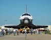
The Shuttle Atlantis is set to launch Sunday on the first in a series of major missions aimed at completing construction of the International Space Station before NASA retires its shuttle fleet in 2010. |
|
| The content herein, unless otherwise known to be public domain, are Copyright 1995-2006 - SpaceDaily.AFP and UPI Wire Stories are copyright Agence France-Presse and United Press International. ESA PortalReports are copyright European Space Agency. All NASA sourced material is public domain. Additionalcopyrights may apply in whole or part to other bona fide parties. Advertising does not imply endorsement,agreement or approval of any opinions, statements or information provided by SpaceDaily on any Web page published or hosted by SpaceDaily. Privacy Statement |