| . |  |
. |
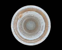
Pasadena CA (SPX) Mar 28, 2006 This color map of Jupiter was constructed from images taken by the narrow-angle camera onboard NASA's Cassini spacecraft, as it flew by the giant planet on Dec. 11 and 12, 2000, on its way to Saturn. This and other images represent the most detailed global color maps of Jupiter ever produced. The smallest visible features are about 120 kilometers (75 miles) across. Each map comprises 36 images covering Jupiter's northern and southern hemispheres that were acquired in two colors every hour for nine hours as Jupiter rotated beneath the spacecraft. Although the raw images arrived in just two colors, 750 nanometers (near-infrared) and 451 nanometers (blue), the map's colors are close to those the human eye would see when gazing at Jupiter. The planet's north pole appears at the center of the image, surrounded by a variety of colorful cloud features, including parallel reddish-brown and white bands, the Great Red Spot, multi-lobed chaotic regions, white ovals and many small vortices. Many clouds appear in streaks and waves due to continual stretching and folding by Jupiter's winds and turbulence. The bluish-gray features along the north edge of the central bright band are equatorial hot spots - meteorological systems such as the one entered by NASA's Galileo probe. Small bright spots within the orange band north of the equator are lightning-bearing thunderstorms. The polar region is less clearly visible, because Cassini viewed it at an angle and through thicker atmospheric haze. Related Links Cassini Jupiter Flyby Images Cassini Images Cassini Home JPL
 Richland WA (SPX) Mar 27, 2006
Researchers at Pacific Northwest National Laboratory said they have uncovered the most detailed picture to date of how oxygen could be manufactured on water-rich but frigid moons in the outer solar system. |
|
| The content herein, unless otherwise known to be public domain, are Copyright 1995-2006 - SpaceDaily.AFP and UPI Wire Stories are copyright Agence France-Presse and United Press International. ESA PortalReports are copyright European Space Agency. All NASA sourced material is public domain. Additionalcopyrights may apply in whole or part to other bona fide parties. Advertising does not imply endorsement,agreement or approval of any opinions, statements or information provided by SpaceDaily on any Web page published or hosted by SpaceDaily. Privacy Statement |