| . |  |
. |
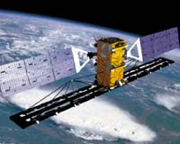
Ottawa ON (SPX) Aug 30, 2005 Canada is resorting to space technology to assert its sovereignty over the Arctic as its military plans a satellite monitoring operation over the region next year. The Canadian Space Agency is paying 400 million Canadian dollars (320 million US dollars) to get Arctic imagery from a British Colombia company, which will launch its Radarsat 2 polar orbiter next summer, the Canadian Press reported Sunday. The satellite, which is expected to operate over a seven-year lifespan, can see in all weather, day or night, 365 days a year, project workers and officials from the Defence Ministry said. Passing over the North Pole 14 times daily, recording images of ships, aircraft - even pollution - at a rate of 3,000 square km per second, the satellite will be the lynchpin in the Canadian military's Project Polar Epsilon. "Polar Epsilon is a transformational first step for Canada inusing space to support the sovereignty and security of the Arcticregion, including maritime security and continental defense together with the U.S.A. at the strategic level," said briefing notes from the Defence Ministry. The project has no connection to the US ballistic missile defense program, the documents stress. Canada will build ground receiving stations near Halifax, capital of the Atlantic province of Nova Scotia, and Esquimalt of British Colombia, to process and relay the images. The Canadian military has undertaken a series of operations in the Arctic since last year to assert Canada's sovereignty as it sees threat to its areas of interest. The operations include an exercise, stepped-up Ranger patrols and patrols by Canadian navy vessels. Arctic sovereignty is becoming more coveted as global warming melts the ice and opens new areas for oil and mineral exploration,said Vincent Rigby, director general of policy and planning at the National Defense. Enhanced vigilance in the region has become more necessary sincethe dispute between Canada and Denmark over Hans Island, a 1.3-km uninhabited Arctic isle, erupted anew when Canadian Defence Minister Bill Graham visited the island in July, analysts say. The island, located in the Kennedy Channel between Danish Greenland and Canada's Ellesmere Island, is claimed by both sides. The two countries were unable to settle the dispute when they drew a border halfway between Ellesmere Island and Greenland in 1973. Related Links Canadian Space Agency SpaceDaily Search SpaceDaily Subscribe To SpaceDaily Express
 Paris (ESA) Aug 29, 2005
A sandstorm obscures the border zone between Pakistan and India's desert state of Rajasthan in this Envisat image. |
|
| The content herein, unless otherwise known to be public domain, are Copyright 1995-2006 - SpaceDaily.AFP and UPI Wire Stories are copyright Agence France-Presse and United Press International. ESA PortalReports are copyright European Space Agency. All NASA sourced material is public domain. Additionalcopyrights may apply in whole or part to other bona fide parties. Advertising does not imply endorsement,agreement or approval of any opinions, statements or information provided by SpaceDaily on any Web page published or hosted by SpaceDaily. Privacy Statement |